This thesis, having been approved
by the special Faculty
Committee, is accepted
by the Graduate School of the
University of Wyoming,
in partial fulfillment of the
requirements
for the degree of Master of
Science
Robert H. Bruce (signed)
Dean of the Graduate School
Date: May 8,
1969
QUATERNARY GEOLOGY OF THE BURNT FORK
AREA, UINTA MOUNTAINS,
SUMMIT COUNTY, UTAH
by
Mark J. Schoenfeld
A Thesis
Submitted to the Department
of Geology and the Graduate School
of the University of Wyoming in Partial
Fulfillment of Requirements for the Degree of
Master of Science
University of Wyoming
Laramie, Wyoming
March, 1969
ABSTRACT
The Burnt Fork drainage
area, on the north flank of the Uinta Mountains, has well‑preserved
Tertiary and Quaternary geomorphic features and Pleistocene
glacial till, Remnants of Oligocene and Pliocene erosion surfaces exist at
elevations greater than 9,500 and 10,400 feet; respectively. Two pre‑Wisconsin surfaces are
found at elevations less than 9,000 feet:
the Burnt Fork surface, formed by fluviatile
erosion and redeposition of
an Eocene conglomerate, and the Eastern surface, a local pediment.
Glacial features include moraines of Bull Lake, Pinedale,
and Neoglacial age~ Pre‑Wisconsin
till may also be present. At least two
Bull Lake and three to five Pinedale advances are represented; Neoglacial deposits include moraines of one Temple
Lake stade and periglacial
Gannett Peak material. The cirque area appears to be in a youthful stage, and cirque morphologies indicate different stages of cirque development.
A tentative theory for these differences suggests that Island Lake and
Burnt Fork Lake cirques developed first, through ice
accumulation and erosion at the heads of major stream valleys. Uplift during Pinedale time
allowed ice to accumulate in the higher area between the cirques,
resulting in the later development of Triplett Lake and Shafe Lake cirques.
Bull Lake and Pinedale terraces are found solely on
the east side of the Burnt Fork valley below the Lower Pinedale front. The terrace sequence suggests a relatively
short interval between the Lever and Middle Pinedale advances and possible
contemporaneous regional uplift, greater in the western part of the range. Periglacial features include rockfalls, stone nets and streams, solifluction
lobes, and protalus ramparts.
CONTENTS
Structural
and Stratigraphic History
Bedrock
Geology of the Burnt Fork Area..
PRE‑WISCONSIN
QUATERNARY GEOLOGY
Descriptions
of Individual Cirque Areas
Theories
of Terrace Development
LIST OF ILLUSTRATIONS
Plate 1a. Quaternary
Geology of the Lower Burnt Fork Area, Uinta Mountains, Utah
Plate 1b.
Quaternary Geology of the Upper Burnt Fork Area, Uinta Mountains, Utah
PLATE 3. PRE‑WISCONSIN
FEATURES
Figure 2.
Terrace profile sketch Map
This study of the Quaternary geology of the Burnt Fork drainage area, Uinta Mountains, Utah. involves a general reconnaissance of fluvial surfaces of aggradation and degradation (including pediments and stream terraces) and glacial and periglacial features, The glacial deposits and geomorphic, features are considered in light of the current model of Rocky Mountain glacial chronology (Richmond, 1965).
Burnt Fork Creek rises in a small
unnamed lake, 40°49'130" N. latitude, 110°59" W. longitude, hereafter
called Meeks Lake, on the north flank of the Uinta Mountains, five miles due
east of South Burro Peak. From there it
flows one‑half mile northwest into Burnt Fork Lake, then in a more
westerly direction for roughly one mile before turning and flowing north‑northeast
down the north flank of the mountains to its confluence with Henrys Fork just north of the Utah‑Wyoming border. The area studied included the Burnt Fork valley and, to a lesser extent, adjacent
highlands east of the creek.
Accessibility to the area in very limited. Dirt
roads and trails leading to the
cirque areas were largely destroyed by heavy flooding in recent years. Intermediate elevations and cirque areas are
now accessible either by pack trail or by jeep along dirt roads extending
south and west from Utah Route 165 (the Sheep Creek Road). However,
most are blocked by snow and spring thaws and are inaccessible after heavy
rains. Ranch roads give access to the lower part of
the area.
Although no previous detailed studies of the Quaternary geology of the Burnt Fork area exist, Powell (1876) and Clarence King (1878) recognized glacial material in the valleys of the north flank of the Uinta Mountains. King (P. 470) noted "well defined glaciation and moraine material down to between 8,000 and 9,000 feet" along Bear River, Smiths Fork and Blacks Fork. Atwood (1909), in his reconnaissance of the Uinta and Wasatch Mountains, included a brief resume of the glacial geology of the Burnt Fork area, noting evidence for two and perhaps three glacial advances. Bradley (1936) separated the glacial chronology of the north flank of the Uintas into three stages which he correlated with the chronology proposed by Blackwelder (1915) for the Wind River Mountains.
Table 1. Comparison of Glacial Chronologies Used by
Different Workers in the Wind River and Uinta Mountains
Bradley mentioned the Burnt Fork area but gave few details. Since Bradley's work no one has published any work on the Quaternary geology in the northern Uinta Mountains,
Field work was carried out in the summer of 1968 using advanced and final copies of U.S.G.S. topographic maps surveyed in 1962 and 1966, scale of 1:24,000.[1] Terrace and moraine heights were measured with a Brunton Compass. Heavy forest cover, lack of accessibility, and inclement weather limited investigation of certain areas.
1However, all section locations are given with regard
to the U.S.G.S. Gilbert Peak, Utah‑Wyoming, Quadrangle, 1905, scale of
1:125,000.
members of the faculty of the Department of Geology at the University of Wyoming, especially
Dr. D. L. Blackstone and Dr. P. 0. McGrew, provided helpful advice and information, as did
Dr. J. D. Love of the U. S. Geological Survey and Prof. Eugene P. Kiver of the Department of Geology, Eastern Washington University.
I also wish to thank Mr. and Mrs. Ruel Triplett of McKinnon, Wyoming; Mr. and Mrs. Charlie Meeks of Burntfork, Woming; and the owners of Spirit Lake Lodge, Utah, for their hospitality and assistance during field work. Mrs. Peggy Deaver typed the manuscript; Gary Sandberg of the University of Wyoming assisted in the preparation of the maps and diagrams. A grant from the University of Wyoming through the Charles S. Hill Memorial Scholarship Fund is gratefully acknowledged. My wife, Chantal, provided encouragement during the writing of this report.
The Uinta Mountains, the largest east‑west trending range in the conterminous United States, lie mostly in Utah, just south of the Wyoming border, except for an eastward extension of some thirty miles into Colorado. The range is about 150 miles long; width varies between 30 and 50 miles. The range crest rises an average of approximately 6,000 feet above the Green River Basin to the north and the Uinta Basin to the south, The highest peak in the range is Kings Peak (13,498 feet), with South Burro Peak (12,727 feet) the highest peak in the immediate vicinity of Burnt Fork Creek.
Structurally the Uinta Mountains are a broad, flat‑topped anticlinal arch, exposing Precambrian rocks along the range's crest and rocks of Paleozoic to Tertiary age along the flanks. The higher parts of the range are eroded into impressive cirques and glacial troughs, and streams have incised canyons as much as 2,000 feet below the surrounding summit levels, forming a rugged topography. Floral zones, in ascending order, include juniper, shrubs, aspens, pine, spruce‑fir, with alpine shrubs and grasses above timber line (Untermann, 1964).
A brief summary, based essentially on
the work of Forrester (1937), for the pre‑Cenozoic development of the
Uinta Mountains follows.
Precambrian history of the Uinta region involved deposition in the Uinta trough, an east‑west trending arm of the Wasatchian geosyncline, of two major units: (1) the Red Creek Quartzite of Archean age, and (2) conformable above it, the Uinta Mountain Group (or Uinta Series) of Algonkian age. In turn these units are overlain disconformably by Cambrian shales and quartzites (Cohenour, 1959). The Cambrian rocks lie with well‑developed angular unconformity below limestones of Mississippian age and later sediments. South of the Uinta Mountains Mississippian or Mesozoic sediments directly overlie rocks of Archean age (Butler et al, 1920), thus indicating a late Precambrian and early Paleozoic source for sediments in the Uinta trough. During Carboniferous time the rising Uncompaghre Range of the "Ancestral Rockies" provided a southeastern source of material for the trough. A continuous sequence of shallow‑water, near‑shore and eolian deposits ranging from Mississippian through Upper Cretaceous in age interfingers with thicker marine in facies deposits towards the west (Untermann, 1955).
Laramide deformation initiating the Uinta Mountains began in late Cretaceous time in response to "deepseated compressive or torsional stresses, acting from southerly and southwesterly directions on the sediments deposited in the Uinta trough" (Forrester, 1937, p. 655). The Uinta arch became a broad, low‑dip anticline, slightly asymmetrical towards the north, with a total uplift for the first stage of the Laramide orogeny estimated between 10,000 and 12,000 feet. However, contemporaneous erosion was removing sediments from the central part of the range and depositing then in adjacent basins, and thus the height of the mountains never approximated the fall amount of uplift. These sediments were themselves eroded and redeposited during the Eocene as the Wasatch Formation, though local remnants of Paleocene Fort Union Formation remain on the east side of the range. After uplift ceased the region was reduced to a low, rolling surface at about the close of the Eocene.
During the late Eocene and early Oligocene, vertical uplift and large‑scale faulting of the Uinta Mountains tilted and warped the Eocene sediments, bringing them into contact with Paleozoic and Mesozoic units. Uplift of the center of the range during this time was approximately 25,000 feet, with greatest uplift at the West end of the range. Major faults of this period (such as the Uinta Fault, Henrys Fork Fault, North Flank Fault, etc.), are normal, high‑angle strike faults, formed in response to tensional, vertical stresses believed to be associated with emplacement of a batholithic core in the area previously deformed by folding (Forrester, 1937). A period of erosion followed, during which the two major erosion surfaces of the Uinta Mountains, the Gilbert Peak surface (Late Oligocene‑Early Miocene) and the Bear Mountain surface (Late Miocene‑Early Pliocene) were formed (Bradley, 1936). During Early Pliocene time an epeirogenic uplift affected the region as well as the Colorado Plateau, Wasatch, and Great Basin Ranges. This last period of uplift is estimated to have been between 8,000 and 10,000 feet and gave the Uinta Mountains a total uplift of approximately 45,000 feet, though less than one‑third of this is topographically expressed.
Precambrian rocks of the Burnt Fork region are mainly medium‑grained, reddish‑purple quartzites called the Mutual Formation of the Uinta Mountain Group (Stokes and others, 1963). The crest of the Uinta Mountains is developed in this unit for many miles to the east and west of Burnt Fork and is widely exposed in the cirque walls above the 10,000 foot contour. Preserved sedimentary structures such as crossbedding, convolutions, and ripple marks indicate a probable shallow‑water or fluviatile origin prior to low‑grade metamorphism. Kinney (1955) observed similar sedimentary structures in this unit in the Duchesne River‑Brush Creek area along the south flank of the range.
Interbedded shales and quartzites of possible Precambrian age crop out near Burnt Fork along the eastern wall of an intermittent stream valley just north of McCoy Park. They are distinct from and younger than the Mutual Formation, but I do not know their exact age. Stokes and others (1963) indicate only Quaternary till at the described location. Three to four miles south of this outcrop the Red Pine Shale of Upper Precambrian age has been mapped (Stokes and others, 1963), although Weeks (1907) shows Lodore Formation (Cambrian) in approximately the same location. The units mentioned above are probably either Red Pine Shale or Lodore Formation cropping out farther south than previously recognized.
Downstream from and stratigraphically above the Precambrian rocks are two prominent ridges. The southernmost of these ridges is herein called the first limestone ridge; the northern one, the second limestone ridge. The second limestone ridge is composed of a massive, granular, white to gray, friable limestone. Emons (1877) considered these ridges to be Jurassic, but Weeks (1907) and Stokes and others (1963) have mapped the rocks in them as Carboniferous. The calcareous unit seems to correspond most closely to the Morgan Limestone of Carboniferous age as described by Kinney (1955), and therefore I also consider them to be Carboniferous. Weber Sandstone (Carboniferous) may also be present. Schultz (1919) and Stokes and others (1963) mapped Park City Formation (Permian) on both sides of Burnt Fork just north of the Carboniferous units. I did not find any outcrops of this unit in place.
Just below the second limestone ridge, west of Burnt Fork, a hogback ridge approximately half a mile long and 120 feet high parallels the eastward‑striking Carboniferous formations. This hogback consists of several deep red to buff sandstone units having different hardnesses and lithologies, and appear to most closely resemble the Woodside and succeeding units (Thaynes and/or Chinle) of Triassic age as described by Kinney (1955). To the east, another prominent hogback consists of a medium‑grained, buff to white, highly calcareous, extremely friable sandstone of probable eolian origin. This unit is probably the Navajo (Nugget of Wyoming) or Entrada Sandstone of Jurassic age as described by Kinney (1955). However, Stokes and Others (1963) mention neither unit in the Burnt Fork area and record Woodside in the area east of Burnt Fork Creek, where I doubt that it is present. These discrepancies indicate a need for farther study of the bedrock geology of the Burnt Fork area.
A conglomerate of probable Eocene age, hereafter called the Widdop Peak Conglomerate, is exposed along the east side of Widdop Peak and below a gravel‑covered surface west of Burnt Fork Creek. This unit will be discussed in more detail on pages 21 and 22. A low hill which crosses the state line between the east and west branches of Burnt Fork
Plate 1a. Quaternary Geology of the Lower Burnt Fork
Area, Uinta Mountains, Utah
contains chert pebbles and limestones of various lithologies mapped by Stokes and others (1963) as Middle Eocene Bridger Formation. These units may be correlative to the Burnt Fork White Layer of Horizon C of the Bridger Formation as described by Matthew and Granger (1909, p. 296). No post‑Eocene bedrock occurs in the Burnt Fork region. The Bishop Conglomerate (Late Oligocene‑Early Miocene), which is well‑exposed at the top of Cedar Mountain about 4 miles north of the state line, was believed by Hares (1926) to be of glacial origin but is in reality a fluviatile unit derived from older rocks (Rich, 1910; Bradley, 1936).
Four separate erosion surfaces ranging from Late Oligocene to Early Pleistocene in age are reported in the Uinta Mountain region. These were first described by Bradley (1936), who formally named them the Gilbert Peak surface (Late Oligocene‑Early Miocene), Bear Mountain surface (Late Miocene‑Early Pliocene), and Lyman and Tipperary benches (Early Pleistocene). Kinney (1955) noted equivalent surfaces on the south flank of the range. Remnants of the Gilbert Peak and Bear Mountain surfaces are found in the Burnt Fork area, the Lyman and Tipperary benches are restricted to the area around Blacks Fork and Smiths Fork since they owe their origins to stream activity in that district.
The Gilbert Peak surface is the oldest and best‑preserved surface in the Uinta region; remnants extend from high on the mountain flanks to 35 miles out in the Green River Basin at gradients between 400 and 55 feet per mile and all are capped by the Bishop Conglomerate. In the Burnt Fork vicinity remnants of this surface are the high flat area known as Kabell Ridge west of the upper reaches of Burnt Fork, and the unnamed flat area to the east between Burnt Fork and Fish Lake Creeks. In addition, "the whole crest line of the Uinta Range from South Burro Peak for many miles eastward is a well‑preserved part of this ancient topography" (Bradley, 1936, p. 171). Bradley considers the Gilbert Peak surface a pediment formed in an arid climate rather than a peneplain characteristic of a humid climate, as suggested by Rich (1910). The streams which carved the surface also deposited the Bishop Conglomerate. The surface apparently extends on the south flank of the range (Kinney, 1955).
The westermost extension of this surface is in the Burnt Fork area, just south of the first limestone ridge and east of Beaver Meadows, and is usually capped by the Browns Park Formation‑‑a white quartzitic conglomerate overlain by a white sandstone, tuffaceous sandstone, and glassy tuff. The westernmost part of the surface is capped by glacial till. This surface evidently formed under the same conditions as the Gilbert Peak surface (Bradley, 1936). Whether the Bear Mountain surface extends to the south flank of the range is problematical. Kinney (1955) describes remnants of the Lake Mountain surface, also of Miocene‑Pliocene age, at several localities in the Uinta River‑Brush Creek area; however, he mentions no correlation with the Bear Mountain surface, and I find no other reference to the Lake Mountain surface. Thus correlation of the Lake Mountain and Bear Mountain surfaces is uncertain.
Recently Hanson
and others (1959) found remnants of the Brown Park Formation below the Bear
Mountain surface in the vicinity of Red Canyon, several miles east of Burnt
Fork. They felt that the Bear Mountain
surface projected above rather than below the Browns Park Formation (as Bradley
claimed) and merged with the tops of Goslin, O‑Wi‑Yu‑Kuts, Cold Spring, and other mountains on the east end of
the range. Discordances in the altitudes
of the Gilbert Peak and Bear Mountain surfaces were attributed to tectonic
activity prior to, during, and after deposition of the Browns Park
Formation. Tectonism was accompanied by
a change in stream regimen from degradation to aggradation in the interval
between formation of the Bear Mountain surface and deposition of the Browns
Park Formation (possibly due to heavy falls of volcanic ash), in opposition to
Bradley's idea that the two were formed simultaneously because of climatic
change. Untermann
(1964) believes that the Bishop Conglomerate is part of the Browns Park
Formation.
A third, previously unmentioned surface of probable late Tertiary age in the Burnt Fork area can be seen north of Fish Lake on the eastern side of Burnt Fork. Herein called the McCoy Park surface, it extends eastward for several miles and grades into the floor of Round Park, north of Tamarack and Hidden Lakes, where it is drained by the Sheep Creek rather than the Burnt Fork system. The surface is largely capped by forested glacial till and not by Bishop Conglomerate or Browns Park Formation. Where this till veneer is missing the surface becomes a grassy marshland. The main part of the surface extends northward from Fish Lake for about two miles (Plate 3, Figure 1). Its elevations range from about 10,700 feet on the south to roughly 10,400 feet on the north.
Plate 1b. Quaternary Geology of the Upper Burnt Fork
Area, Uinta Mountains, Utah
A distinct break in slope separates it from the more heavily glaciated area to the north.
The age and origin of the McCoy Park surface are uncertain. Bradley did not include the McCoy Park surface as a part of the Gilbert Peak surface, although the slightly higher area to the east between McCoy Park and the Burnt Fork valley was included. I distinguish the McCoy Park surface from the Gilbert Peak surface on the basis of three lines of evidence:
1. The Bishop Conglomerate does not cap the McCoy Park surface.
2. An east‑west profile (Plate 2, Figure 1) shows that the McCoy Park surface projects several hundred feet below the crest of Kabell Ridge, which Bradley (1936) considered part of the Gilbert Peak surface. Just below the eastern edge of Kabell Ridge a small "shoulder" which probably represents the westernmost extension of the McCoy Park surface before dissection by Burnt Fork Creek during Pleistocene time. Kabell Ridge correlates well with the Fish Lake‑Burnt Fork Lake ridge to the southwest.
3. A north‑south profile across McCoy Park from Fish Lake to the break in slope to the north (Plate 2, Figure 2) shows the McCoy Park surface, even where capped by glacial till, to be much less steep than Kabell Ridge. The average gradient of the McCoy Park surface is roughly 140‑150 feet per mile while Kabell Ridge slopes approximately 400 feet per mile, which Bradley cites as the gradient of the Gilbert Peak surface remnants high on the range's north flank.
It is even less likely that the McCoy Park surface is a remnant of the Bear Mountain surface. The Bear Mountain surface is confined almost exclusively to the east of the McCoy Park area and is several miles farther north, at elevations as much as 1,000 feet lower than the McCoy Park surface. Also, no evidence of Tertiary rocks resembling Browns Park Formation, which usually caps the Bear Mountain surface, is found in McCoy Park. The McCoy Park surface, therefore, appears to represent a later cycle of erosion that is post‑Bear Mountain (i.e., post‑Early Pliocene) but pre‑Wisconsin, because till of Pinedale and Bull Lake (?) age rest upon it. Thus the McCoy Park surface probably represents the local equivalent of the "Subsummit" erosion surface and is Middle or Late Pliocene in age. Also, Mackin (1938) believes that the Gilbert Peak surface may be Pliocene in age. If this is true the McCoy Park surface must be Middle or Late Pliocene. A Pliocene age for the "Subsummit" surface has been postulated by numerous other workers (e.g.. Lee, 1922; Atwood and Atwood, 1938;
Wahlstrom, 1947; Mackin, 1947; Van Tuyl, 1955; Love, 1960; Scott,1965; Mears, personal communication). Other proposed ages for the "Subsummit" surface are Precambrian (Hughes, 1933) and Eocene (Van Tuyl and Lovering, 1935; Lovering and Goddard, 1950; Knight, 1953). Neither of these ages seem reasonable for the McCoy Park surface.
Many of the early workers (Lee, 1922; Van Tuyl and Lovering, 1935) favored the concept of peneplanation for the formation of high level erosion surfaces. Van Tuyl and Lovering (p. 1298) also applied this concept to local “park" areas in the Colorado Front Range:
Most of these [parks] represent remnants of partial peneplains
developed in areas of lesser resistance to erosion. . . . locally,
sheet erosion and pedimentation may have been
important in the development and modification of these features.
More recently, however, the "Subsummit" and similar erosion surfaces have been considered as pediments (Johnson, 1931; Bradley, 1936; Howard, 1941; Mackin, 1947). A pediment is generally defined as an inclined erosion surface of fluviatile origin which truncates soft and resistant bedrock indiscriminately and is often covered with a gravel veneer. Erosion is controlled by local base level rather the ultimate bass level of streams. The major advantage of this hypothesis is that it eliminates the need for several thousand feet of uplift since Pliocene time to raise such surfaces to their present elevations (Mackin, 1947). I believe that the McCoy Park surface originated in a topographic low of the older Gilbert Peak surface and developed as a local pediment through combined headward erosion and lateral planation of the Burnt Fork and Sheep Creek drainage systems because:
1. The higher area directly between the McCoy Park surface and the Burnt Fork valley is considered by Bradley a remnant of the Gilbert Peak surface, a conclusion which seems to me to be valid on the basis of the east‑west profile across the McCoy Park surface (plate 2, figure 1).
2. In the McCoy Park area Precambrian (?) sediments to the south and crystalline quartzites of the Mutual Formation to the north, the only two units present, are both truncated by the surface.
The resistant Bishop Conglomerate capping the Gilbert Peak surface probably acted as a local base level, reducing the cutting power of the streams, and thereby accounting for the relatively small extent of the McCoy Park surface. Rich (1938) points out with regard to peneplanation that isolated spurs, shoulders, and similar features (such as in plate 2, figure 1) are divide features above regional base level and are therefore suspect for theorizing multiple erosion surfaces unless the nature of the bedrock is taken into account or a general uniform lowering of the area is postulated. In the McCoy Park area, however, there is a uniformly resistant bedrock (Bishop Conglomerate), and formation of such features would appear to depend solely upon the position and lateral cutting power of local streams with regard to local rather than regional base level, if the concept of pedimentation is employed. Also, no uniform lowering of the area is needed to account for the position of the McCoy Park surface.
The lower elevations of the Burnt Fork area contain two erosion surfaces of pre‑Wisconsin age. The more extensive of these surfaces, west of the Burnt Fork valley, appears to have been formed by aggradation rather than by removal of pre‑existing bedrock. The smaller of the two, on the east side of the valley, is a locally‑developed pediment. To the writer's knowledge neither of these features has been described in detail.
The surface to the west of the Burnt Fork valley, hereafter called the Burnt Fork surface, is an extensive gravel‑covered area extending northward for several miles across the Utah‑Wyoming and westward towards Beaver Creek (Plate 3, Figure 2). It has a low, hummocky topography occasionally broken by intermittent stream valleys with vertical sidewalls. Maximum elevation is approximately 9,000 feet. There are suggestions that the surface may topographically have more than one level. The gravel veneer contains few boulders, although large pebbles and cobbles are common. Two pebble counts of 50 pebbles each, made at localities 30 feet apart on a part of the surface above a roadcut, SE¼ SE¼ sec. 5. T. 3 N., R. 17 E., yielded the following results: limestone, 67%; quartzite 17%; chert, 11%; conglomerate, 4%; sandstone, 1%. In many instances chert and limestone are found together in the same pebble, although quartzite and limestone are never found together. The chert‑limestone Pebbles may have their origin in unmapped outcrops of Park City Formation (Schultz, 1919; Kinney, 1955).
I feel that the Burnt Fork surface formed from fluvial reworking of the Widdop Peak Conglomerate. A study of the exposures of the conglomerate along the west side of the Burnt Fork valley shows that the pebbles and cobbles generally exhibit a fairly high degree of roundness and sphericity. Some are over a foot in diameter, although most diameters appear to be about four or five inches. Limestone, chert, quartzite, and chert‑limestone pebbles predominate. The matrix is tan‑brown and highly calcareous. Dip of the conglomerate is 30° northwest; strike was estimated at roughly S 62° W. Exposures along Widdop Peak differ from those along the Burnt Fork valley in that the average size of the pebbles is noticeably smaller and the outcrops appear to be nearly horizontal, indicating some structural modification. A count of 100 pebbles made in the exposures near the valley yielded almost identical results with the counts made on the surface itself, lending support to the hypothesis that the conglomerate was the source of material for the Burnt Fork surface.
The conglomerate along the valley overlies a light brown, friable, calcareous sandstone 5 feet thick. The lower two feet of the sandstone are homogeneous with well‑developed horizontal bedding but only slight indications of cross‑bedding. Scattered lenses of small pebbles up to six inches in diameter are found throughout the upper three feet of the sandstone. No such unit was observed in contact with the conglomerate outcrops along Widdop Peak. The age of the Widdop Peak Conglomerate is uncertain, as no distinctive fossils were found in it. Lithologically it is distinct from the Bishop Conglomerate, and the fact that the Bishop Conglomerate on top of Cedar Mountain projects several hundred feet higher than the Widdop Peak Conglomerate indicates that the latter was formed during a separate cycle of erosion and deposition. Bradley (1936) stated that the Widdop Peak Conglomerate forms the main mass of Phil Pico Mountain (Mount Corson of the early surveys) just east of the Burnt Fork valley, and believed that it represented a local conglomeratic facies of the Bridger Formation. Weigman (1964) describes a similar unit several miles to the east, near Little Mountain, as a local fanglomerate within the Middle Wilkins Peak member of the Green River Formation (Lower Eocene). Dr. Paul 0. McGrew (personal communication) feels that it may represent the equivalent of a basal Eocene conglomeratic unit in Lucerne Valley, some 25 miles east of Burnt Fork, or a local shore facies of the Laney Shale member of the Green River Formation. Until definitive criteria can be established, therefore, it seems best to consider the Widdop Peak Conglomerate as probably Eocene in age.
A pre‑Wisconsin age for the Burnt Fork surface is based on three lines of evidence:
1. Cappings and cups of caliche, often 1/8 of an inch or more in thickness, are found on many pebbles of various lithologies.
2. Occasional boulders of Uinta Mountain Quartzite (Mutual Formation) are found on the surface. These are much more weathered and lichen‑covered than boulders of similar lithology found on Bull Lake till in the Burnt Fork valley.
3. A soil believed to be of pre‑Wisconsin age is found in a roadcut just below the localities where the pebble counts mentioned earlier were made (Plate 3, Figure 3). The cut exposes a small‑pebble conglomeratic lens at its base overlain by a podzolic soil 2 to 2½ feet thick, capped by an A horizon of Recent (?) development. The soil consists of an upper B horizon and lower Cca horizon of variable thicknesses.
PLATE 3. PRE‑WISCONSIN FEATURES
Figure 1. View southward across McCoy Park Surface towards Burnt Fork Lake Cirque
(middle background). To right is Triplett Lake Cirque. Ridge in left background is a remnant of the Gilbert Peak Surface; pine‑covered ridges closer to camera are
Pinedale (?) till. Boulders in foreground may represent fossil stone nets.
Figure 2. View northwest across Burnt Fork Surface towards Cedar Mountain. The top of
Cedar Mountain is capped by Bishop Conglomerate.
Figure 3. Soil profile exposed in a roadcut through the Burnt Fork Surface. Lower light unit is the Cca horizon, upper dark units is the B horizon. Note stringers of Cca horizon in upper unit.
Figure 4. View eastward across the Burnt Fork valley. Hogback ridges to right are Jurassic
sandstone; the one to the left is capped by Burnt Fork gravel. Between them is the
pre‑Wisconsin Eastern Surface; in background is Phil Pico Mountain. Ridge in
foreground is composed of Triassic units.
At the place measured the B horizon is a hard, tan‑brown, sandy layer, 1½ feet thick, having a blocky structure. The Cca horizon is six to seven inches thick, gray‑white, fairly hard, and somewhat more clayey in consistency than the B horizon. Stringers of the Cca horizon are scattered throughout the B zone and are sometimes found in slope wash where mass wasting has covered the profile. The highly calcareous nature of both horizons probably results in part from the high percentage of limestone on the surface. The soil seems to be similar to soils of Sangamon (?) age described by Scott (1963) and Richmond (1965), although the thicknesses of the horizons are less than they recorded. This may be due to a progressive thinning of the soil towards the mountains. These considerations point rather conclusively to a pre‑Wisconsin age for the Burnt Fork surface.
The small pre‑Wisconsin surface on the east side of the Burnt Fork valley, NE¼ SW ¼ sec. 20, T. 3 N., R. 17 E., hereafter called the Eastern surface, is a small pediment bounded on the northwest by a series of stream terraces, on the northeast by a gravel‑covered sandstone hillock, and on the south by the Jurassic sandstone hogbacks (Plate 3, Figure 4). This surface has much less of a gravel veneer than the Burnt Fork surface; lithologies present include gray Carboniferous limestone, buff Jurassic sandstone, and Uinta Mountain Quartzite (Mutual Formation). The gravel capping the sandstone hill on the northeast is the same that occurs on the Burnt Fork surface. Presumably this surface extended across the Burnt Fork valley before being eroded in pre‑Wisconsin time. The most unique feature of the Eastern surface is its flaming red color, very similar to the Woodside Formation, which is probably why Stokes and others (1963) mapped this area as Woodside. However, no evidence of Woodside Formation or its equivalent was found in the vicinity of the Eastern surface. The red color most likely results from extensive leaching of iron minerals (?) in the Jurassic sandstone. An exposure of the sandstone underlying the Burnt Fork surface gravel shows well‑developed layering of various colors, probably formed through groundwater action, one of these layers is bright red and resembles the color of the Eastern surface. Mears (personal communication) reports that deposits on some pre‑Wisconsin surface in the Laramie Basin display the same deep red color seen in the Eastern surface. A second reason for considering the Eastern surface as pre-Wisconsin is the occurrence of Uinta Mountain Quartzite boulders on the surface. These boulders were probably washed onto the surface from the strike valley between the Carboniferous and Jurassic hogback ridges, which contains Bull Lake or pre‑Wisconsin outwash. The surface most likely existed before the quartzite was washed onto it and therefore is probably pre‑Wisconsin. The Eastern surface is considered to be a pediment feature because it is cut at least 200 feet into the Jurassic sandstone and overlying gravel, truncating them indiscriminately.
The current model of Rocky Mountain glacial chronology (Table 1) was formulated by G. M. Richmond (1948, 1965), based on earlier work by Blackwelder (1915). In this chronology the Wisconsin is divided into two major stages, Bull Lake (Early Wisconsin?) and Pinedale (Late Wisconsin). "Pre‑Wisconsin" glaciations are separated, from earliest to latest, into Washakie Point, Cedar Ridge, and Sacagawea Ridge. However, correlations with the Midcontinent region of the United States and Europe proposed by Richmond (1965, p. 227) present certain difficulties. Regarding Europe, Richmond shows the "Göttweig Interval" separating the Riss and Early Würm glaciations, with the Early Bull Lake equivalent to the Riss; but European workers such as Penny (1964) and Gross (1966) have shown conclusively that the "Gottweig Interval" is actually an interstadial (or at least a period of climatic oscillation warmer than full‑glacial) separating the Early and Main Würm, not the Riss and Early Würm. Readjustment of Richmond's chronology in light of this fact makes the Bull Lake correlative to the Early Würm, the Sacagawea Ridge correlative to the Riss, etc.
Richmond's correlations with the Midcontinent region are also unclear. He appears to show the Early Bull Lake as equivalent to part of the Sangamon interglacial, yet no description of the Sangamon I have seen (e. g. Wright and Ruhe, 1965; Wayne and Zumberge, 1965) includes glacial material within the Sagamon sequence, Also, Richmond (1960, 1965) correlates the Late Bull Lake (>42,000 years B.P.) with the "Iowan" glaciation of the Midcontinent region, dated at >29,000 years B.P. (Ruhe and Scholtes, 1959) and accepted by Frye and Willman (1960). However, Leighton (1960, 1968) dates the "Iowan" at <22,000 years B.P., or Classical (Late) Wisconsin. Until these differences are resolved it seems preferable to simply place the Bull Lake and Pinedale as correlative to the Wisconsin, the Sacagawea Ridge to the Illinoian, the Cedar Ridge to the Kansan, and the Washakie Point to the Nebraskan.
Kiver (1968, p. 23) has outlined thirteen field criteria applicable in correlating moraines and geomorphic features of the Upper Laramie Valley with their type localities in the Wind River Mountains. These same criteria were used, though in a more general way, for the Burnt Fork area. The most useful criteria proved to be preservation of topography and topographic relations to features to each other within the area studied. Criteria of secondary Importance included boulder size and frequency, degree of lichen cover on boulders, distance of terminal moraines from cirques, and relative freshness of cirques. Criteria such as soil development, rock‑and till‑weathering ratios, and actual terrace heights above modern floodplain were of questionable value in this study because of (1) the extreme abundance of Uinta Mountain Quartzite, which is a very poor soil former and highly resistant to weathering, and (2) possible Pleistocene to Recent tectonic activity affecting the relationships of terraces to present stream level.
In the Burnt Fork area there are no glacial deposits of definite pre‑Wisconsin age, although possible pre‑Wisconsin (Sacagawea Ridge?) material may be present. In the lower elevations occasional patches of till beyond the main mass of Bull Lake moraine may represent exhumed pre‑Wisconsin material. These patches of material generally resemble Bull Lake till in degree of weathering and lichen cover. Small‑individual boulders of Uinta Mountain Quartzite also extend westward beyond Lateral moraines of Bull Lake age almost to the base of Widdop Peak.
Bradley (1936, p. 194) described what he believed to be a mass of Little Dry (pre‑Wisconsin) morainic material between Burnt Fork and Beaver Creek:
Apparently. . . the great mass of morainic material
south of Henrys Fork between the Middle Fork of Beaver Creek and Burnt Fork
belong to this oldest stage. The base of
the glacial debris at [this] locality is some distance above the present valley
floors and presumably rests on a remnant of the Bear Mountain surface, though
this is by no means certain. The great
accumulation of moraines between Burnt Fork and the Middle Fork of Beaver
Creek, which makes up the greater part of a barren group of hills locally known
as the "Bald Range", appears to be the combined deposit left by
glaciers of the Little Dry stage that came down Henrys Fork, the West and East
Forks of Beaver Creek, and Burnt Fork.
However, Bradley also stated (p. 195) that these moraines are located "farther north [of the Blacks Fork moraines], near the State boundary”. It thus appears that Bradley considered the Burnt Fork surface north of Widdop Peak to be of glacial origin. As already noted, I believe that the Burnt Fork surface formed from fluvial reworking of the Widdop Peak Conglomerate rather than by glacial action. Three lines of evidence support this conclusion:
1. The almost identical results obtained by pebble counts from the Burnt Fork surface and the conglomerate exposures on the west side of the Burnt Fork valley indicate a definite relationship between the two.
2. The Burnt Fork surface is noticeably deficient in Uinta Mountain Quartzite, although this is the sole unit found in deposits of definite glacial origin in the valley. The few quartzite boulders on the surface are far more highly weathered and lichen‑covered than any found on Bull Lake till.
3. Pre‑Wisconsin till reported from other areas of the Rocky Mountains usually has at best a very low, gently rolling topography (Richmond, 1965; Kiver, 1968; Mears, personal communication). The Burnt Fork surface has a much greater topographic expression than one would expect to find on pre‑Wisconsin till.
However, although the Burnt Fork surface does not appear to be of glacial origin, true pre‑Wisconsin till may still exist in the Burnt Fork area. The exhumed patches of glacial material outside the boundaries of Bull Lake moraine may be pre‑Wisconsin; also, part of the mass of morainic material on the McCoy Park surface between Fish Lake and Tamarack Lake may be of pre‑Wisconsin age. Atwood (1909) mapped this whole area as “later epoch" (Pinedale), but I believe that the approximate extent of Pinedale till on the McCoy Park surface is not more than half a mile east of the Burnt Fork valley, based an a cursory inspection of the topographic relationships of glacial material in the vicinity of Fish Lake. If this is true the till east of the Pinedale material is Bull Lake and/or pro‑Wisconsin in age. More work needs to be done in differentiating glacial deposits in the McCoy Park area.
A small ridge of material which resembles a highly eroded lateral moraine is found on the Eastern surface at the base of the Jurassic hogbacks. This ridge contains approximately 60% Uinta Mountain Quartzite and 40% sandstone and limestone from the nearby Jurassic and Carboniferous hogbacks. It therefore is distinctly different from till of Bull Lake and later age, which is entirely quartzitic. However, the fact that the ridge is trenched on both sides suggests that it may be a torrent levee rather than a glacial moraine. Mears (personal communication) reports similar features in various mountain areas which are also considered torrent levees.
Till of Bull Lake age is found below the Lower Pinedale front between Burnt Fork Creek and the Burnt Fork surface. Minimum elevation is just over 8,000 feet. Most of this material was correctly mapped as “earlier epoch" by Atwood (1909), although some of his "earlier epoch" deposits may be pre‑Wisconsin in age and in at least one instance they resemble an outwash terrace rather than actual till. There is little doubt of the glacial origin of these deposits since, as Atwood pointed out (p. 36), the quartzite boulders stand in sharp contrast to the nonquartzitic material east and west of the valley. The smooth surface on many of the boulders, highly suggestive of ventifacts (Sharpe, 1949), and hummocky topography of the deposits are also suggestive of a glacial origin. Identification of this material as Bull Lake age is based on preservation, continuity, and distinctiveness of topography, degree of lichen cover and average size of the boulder, and the occurrence of the till downstream from the imposing Lower Pinedale front.
The most prominent Bull Lake deposit is a well‑preserved lateral moraine which extends almost a mile southwestward from the front of the Bull Lake morainic complex to the vicinity of the Wasatch National Forest boundary gate, where it disappears under ground moraine and material washed in from the slopes of Widdop, Peak (Plate 1a). The eastern slope of this moraine stands some 55 feet above the general level of the ground moraine‑outwash material to the east but only 15 to 20 feet above the ground surface on the west. The crest of the moraine has a heavy concentration of quartzite boulders (as do all glacial deposits in the Burnt Fork area), probably representing a lag concentrate formed through removal of finer material by meltwater and eolian action (Flint, 1957, p. 118).
Approximately 1000 feet to the east is another ridgelike form which probably represents the counterpart of the above lateral moraine. This "eastern" moraine is approximately 2500 feet long and stands 40 feet above the present level of Burnt Fork. It is 20 feet above the ground moraine‑outwash material on the west. The crest of this moraine is flatter than that of the "western” lateral moraine, averaging 20 feet in width. Although the crests of both moraines support growths of sagebrush, the flanks of the "eastern" moraine also support growths of aspen, which the "western" moraine does not. This may reflect the proximity of the "eastern" moraine to groundwater provided by Burnt Fork Creek. The "eastern" moraine is also less arcuate in form than the "western" moraine.
I believe that the moraines described above represent the second of two major Bull Lake stades. This idea is based on the preservation of glacial material in the small area between the "western" Bull Lake lateral moraine and the Burnt Fork surface to the west (Plate 1a). Material here consists of hummocky ground moraine, more rolling than Upper Bull Lake ground moraine (which was subsequently affected by Pineale outwash), and remnants of a low, dissected lateral moraine. This moraine runs parallel to the Upper Bull Lake "western" lateral moraine for approximately half a mile before it curves eastward and is truncated by the "western" moraine (Plate 4, Figure 3). It does not reappear east of the "western" moraine. Possibly this material may represent ablation moraine derived from Upper Bull Lake tills, but the hummocky topography and truncation of the lateral moraine suggest an earlier stade of the Bull Lake glaciation.
The front of the Bull Lake morainic complex (Plate 4, Figure 1), SE¼ NE¼ sec. 17, T. 3 N., R. 17 E., also suggests a two‑stade Bull Lake glaciation. Near its western margin the front consists of two steps, the lower one 20 feet above the level of the outwash to the north, the upper 30 to 36 feet above the outwash. The steps gradually merage eastward until the second step disappears near the spot where the "western" moraine joins the front. This second stop therefore probably is the westernmost part of the Upper Bull Lake front, overriding all except a small part of the Lower Bull Lake material.
Directly in back of the upper stop are two noteworthy features. One is an unusually high, almost conical‑shaped accumulation of glacial material at the junction of the upper step with the Burnt Fork surface, suggesting a kame‑like ice contact feature. The second is a small circular marshy area directly in back of the upper step (Plate 4, Figure 2). This area is very grassy, contains few boulders, and fills with water after heavy rains. Most likely this is either a stagnation feature, formed when retreating Bull Lake ice reached a short period of equilibrium and later filled with finer material brought in by fluvial or eolian actions, or a kettle hole formed from a detached block of stagnant ice during the Lower Bull Lake advance. Similar features have been reported by Kiver (1968) in the Southern Medicine Bow Mountains.
Whether the Burnt Fork surface extended across the valley immediately prior to Lower Bull Lake time is uncertain; it may have been previously eroded by glacial and/or fluvial action related to preWisconsin glaciation. Since Lower Bull Lake time, however, the surface has been eroded back slightly to the west, as newly‑developed alluvial fans composed of material from the surface are found at the mouths of intermittent stream valleys on the east flank of Widdop Peak and the Burnt Fork surface, overlying Bull Lake till. The Upper Bull Lake ice was evidently somewhat thinner than the Lower Bull Lake ice when it reached the lower elevations because (1) it failed to override the Lower Bull Lake front and (2) the Upper Bull Lake lateral moraines are much closer together than the Lower Bull Lake lateral described above and its possible counterpart (?) at the base of the second limestone ridge below the Lower Pinedale front.
Upstream, south of the Wasatch National Forest boundary gate, deposits of the two stadials become indistinguishable and must be treated as undifferentiated Bull Lake. In the strike valley immediately west of the Triassic hogback, Bull Lake till extends westward for almost a mile before it crosses and covers the east slope of the hogback. It can also be traced at least half a mile westward in the valley between the second limestone ridge and the Triassic hogback (Plate 1a). Apparently the Bull Lake ice not only skirted the edge of the western part of the second limestone ridge and moved westward upvalley but was thick enough to override the Triassic hogback. Any till deposited on the steeper southeast side of the hogback has been subsequently removed by mass wasting.
On the eastern side of the valley Bull Lake till has been almost completely removed. Small patches of a Lower Bull Lake lateral moraine (?) may, as already noted, occur at the base of the second limestone ridge, but the maximum extent of Bull Lake ice cannot be traced on this side of the valley. The outwash material between the Carboniferous and Jurassic ridges may be of Bull Lake age, and it is possible that at least the westernmost Jurassic ridge may have stood as a nunatak during Bull Lake or pro‑Wisconsin time as glacial material is found along its southern and eastern flanks.
Figure 1. Front of the Bull Lake morainic complex. Note lower and upper "steps" representing two stades of the Bull Lake glaciation. In background is the northernmost of the two Carboniferous hogback ridges.
Figure 2. Stagnation feature in back of the Bull Lake front.
Figure 3. View southward showing intersection of Lower and Upper Bull Lake lateral moraines (Lower Bull Lake moraine is closest to camera). Between them is Lower Bull Lake ground moraine. The Lower Bull Lake lateral moraine is cut off in the right side of the picture and does not reappear east of the Upper Bull Lake moraine.
Figure 4. Southwest view showing front of the Pinedale morainic complex. In background are Shafe Lake and Island Lake cirques; the flat area to the right is Kabell Ridge, a remnant of the Gilbert Peak surface.
Till of Pinedale (Late Wisconsin) age is very abundant in the Burnt Fork area. The upper eight miles of the Burnt Fork valley, up to elevations over 10,700 feet near the cirque areas, is covered with till of this glaciation. Deposits of Pinedale age can be distinguished from earlier Bull Lake material by a sharper, better preserved, less rounded topography, average increase in boulder size with occasional boulders reaching two or three feet in diameter, general decrease in degree of lichen cover on the boulders, and heavy growths of pine due to higher elevations of the till.
Several workers have recognized more than one stade within the Pinedale. Richmond (1948, 1965) separated the Pinedale into Early, Middle, and Late stades; Kiver (1968) proposed in addition a two‑fold separation of the Late stade. While I did not extensively map the Pinedale deposits within the Burnt Fork region, at least three and perhaps five individual Pinedale stades seem likely. Separation of individual stades is difficult, however, and must be done primarily by topographic relations with each other only where readily identifiable. Mears and Kiver (personal communication) have tentatively suggested that four or more Pinedale stades can be distinguished in the Blacks Fork region. Atwood (1909) did not differentiate individual stades within his "later epoch", but did map the approximate extent of these deposits as a whole; his mapping coincides roughly with that of the writer. Bradley (1936) largely ignored deposits of his "Smiths Fork" (Pinedale) stage.
The front of the Lower Pinedale (Pinedale I) advance, which represents the earliest and farthest advance of the Pinedale ice, is located in the watergap through the second limestone ridge in the narrowest part of the Burnt Fork valley. It is 21 miles up‑stream from the Bull Lake front at an elevation of approximately 8,740 feet. The front has a fairly steep slope some 70 to 80 feet high (Plate 4, Figure 4) and is clearly visible from the Burntfork‑McKinnon road five miles to the north. The main mass of Pinedale material extends southward from the front both in the valley and on the divides to the east and west. Burnt Fork Creek has incised a narrow, steep‑sided V‑shaped canyon 250 to 300 feet deep between the Pinedale till and the western part of the second limestone ridge. Material related to the Lower Pinedale front is also located on the west side of Burnt Fork, where it rests on a small terrace remnant (?) of Bull Lake age. This material originally formed the thinner western part of the front before being isolated by Burnt Fork Creek.
A lateral moraine of Early Pinedale age is found against the east side of the western part of the second limestone ridge. This moraine first appears at the base of the ridge just south of the narrowest part of the V‑shaped canyon and gradually rises along the south slope of the ridge, covering much of the bedrock, for about three‑fourths of a mile until it enters a clearing at the eastern end of a strike valley between the first and second limestone ridges (Plate 1a). Here it becomes barely noticeable and merges with till of Middle Pinedale age farther south along the edge of the clearing.
Within the main mass of ground moraine south of the Lower Pinedale front are a number of steep‑sided, closed depressions of varying dimensions which appear to be kettle holes. On the west side of Burnt Fork Creek, a series of four such depressions fall in an almost direct line between the eastern and western parts of the second limestone ridge. These depressions may have formed from the combined effects of normal kettle hole development (covering of a detached block of ice by drift which forms a depression when the ice melts) and removal of calcareous bedrock by downward seepage of meltwater. Similar depressions are found on the east side of Burnt Fork; the larger of these contain small ponds while the smaller ones are dry.
Just south of the Lower Pinedale front and resting upon Lower Pinedale ground moraine is a second front, lower and less steep than the former, which I believe is the front of the Middle Pinedale (Pinedale II) advance. This front may be continuous with a sharper front located between the eastern parts of the first and second limestone ridges. The small front and proximity to the Lower Pinedale front indicates that the Middle Pinedale advance occurred shortly after the Early Pinedale and was slightly smaller in magnitude than its predecessor. The existence of two terraces directly in front of the Pinedale complex, the upper an average of barely 10 feet above the lower, lends support to the idea that the Middle Pinedale advance occurred shortly after the Early Pinedale.
Most of the morainic material south of the Middle Pinedale front, including the till on the divide east of Burnt Fork Creek at the "middle elevations” (9,000 to 10,700 feet), is the Middle Pinedale age. In the vicinity of Beaver Meadows, south of the first limestone ridge (Plate 1a), a series of lateral, end, and recessional (?) moraines probably represent smaller pulses of Middle Pinedale ice. Beaver Meadows Lake appears to be bounded on the north by one such moraine and possibly on the south by another. The Burnt Fork‑Beaver Creek divide to the west was not studied, although Atwood (1909) mapped till of the "later epoch" in this area which may also be Middle Pinedale in age.
Material of Upper Pinedale (Pinedale III, IV?, V?) age in the Burnt Fork area can be recognized with certainty only at elevations greater than approximately 10,700 feet, although it may extend somewhat further down the Burnt Fork valley. These deposits, where recognizeable, are distinguished from earlier Pinedale till by a less sharp topography, decrease in boulder frequency with occasional boulders reaching a maximum diameter of 10 feet, slightly less vegetation on the moraines, and less lichen cover on the boulders. I believe that in some cases at least three Late Pinedale advances can be inferred.
Within the past thirty years many workers (see references in Porter and Denton, 1967; Kiver, 1968) have described moraines of post‑Pinedale age in many of the mountain areas of the western United States to which the name Neoglaciation has been applied (Moss, 1951). These deposits represent two major post‑Wisconsin glacial periods, correlated with renewed worldwide glacial activity approximately 2,800 years B.P. and within the last few hundred years. The advances have been named the Temple Lake (Hack, 1943; Moss, 1951; Holmes and Moss, 1955) and Gannett Peak (Richmond, 1965) for their type localities in the Wind River Mountains.
No studies of Neoglacial deposits in the Uinta Mountains are found in the literature. That they are present is confirmed by the writer's work in the Burnt Fork area. Deposits correlative to the Temple Lake and Gannett Peak glaciations are recognized. However, only one Temple Lake stade appears to be present in the Burnt Fork region, although this glaciation is generally considered to have had at least two stades (Richmond, 1965; Porter and Denton, 1967; Kiver, 1968).
Because Upper Pinedale and Neoglacial deposits occur in fairly close proximity to each other, they shall herein be described within the individual cirque area in which they are found.
Four major cirque areas exist at the head of the Burnt Fork valley and are named in this report for the most prominent lake in their vicinity. Only two of these lakes, however, are named on the most recent U.S.G.S. topographic maps of the area (Chepeta Lake and Fox Lake, Utah, quadrangles). The lakes near the middle two cirques are therefore named by the writer, from east to west, respectively, Triplett Lake and Shafe Lake (Plate 1b). The cirque areas under consideration are thus referred to, from east to west, as the Burnt Fork Lake cirque. Triplett Lake cirque, Shafe Lake cirque, and Island Lake cirque. Only the first three were studied in detail.
This cirque area, approximately 10,850 feet in elevation, contains some of the best preserved Upper Pinedale and Neoglacial material in the Burnt Fork region. Burnt Fork Lake (10,640 feet) is bounded on the north by till of Middle Pinedale (?) age and on the south by a Upper Pinedale terminal moraine. This terminal moraine is roughly 40 feet high at the base of the Fish Lake‑Burnt Fork Lake ridge and decreases in height westward until it is only 5 or 6 feet high where it forms the southern boundary of Burnt Fork Lake one mile from the cirque (Plate 5, Figure 1). Burnt Fork Creek has incised a slot some 35 feet deep through this moraine just before reaching Burnt Fork Lake. At its westernmost margin the moraine intersects a lateral moraine which laps against the northeast side of a high, well preserved Middle Pinedale (?) medial moraine between the Burnt Fork Lake and Triplett Lake cirque areas (Plate 1b). The fact that this lateral moraine can be traced a little ways past the front of the terminal moraine south of Burnt Fork Lake indicates that the lateral moraine may represent an earlier advance of the Late Pinedale ice (Pinedale III). The actual extent of this advance, however, is uncertain, as terminal fronts of Pinedale III age appear to be indistinguishable from Middle Pinedale ground moraine.
I feel that the terminal moraine south of Burnt Fork Lake represents a second advance within the Late Pinedale ("Pinedale IV"). Kiver (1968) postulates a "Late Advance" of Upper Pinedale ice in the West Branch and North Fork areas of the Southern Medicine Bow Mountains, although there the moraines extend several miles farther down‑valley than they do in the Burnt Fork area. This may be due in part to the cirques in the Burnt Fork region being generally lower in elevation than those in the area studied by Kiver. Cirques in the West Branch area which were active during Late Pinedale time average over 11,200 feet in elevation (Kiver, 1968, p. 27), while cirques in the North Fork region are even higher. By contrast the cirques in the Burnt Fork area average approximately 10,900 feet in elevation. Also, the east‑West trend of the Uinta Mountains may have created unique orographic and climatic conditions not found elsewhere in the Rocky Mountains. Kinney (1955, plate 3) shows moraine of the "latest glaciation", which he correlates with Bradley's Smiths Fork stage (p. 135), extending several miles down the canyons of the Uinta and Whiterocks Rivers to altitudes as low as 7,300 feet (p. 134). Although he does not divide the "latest glaciation" into individual stades it appears that the Pinedale on the south flank of the range (at least in the Uinta River‑Brush Creek area) was more extensive than on the north flank and therefore Upper Pinedale moraines may more closely approximate in extent equivalent moraines found elsewhere in the Rocky Mountains (Southern Medicine
Bow Mountains, Wind River Mountains, etc,). In the Burnt Fork area the Pinedale III advance may have extended farther down‑valley, its front now part of the mass of forested till between the Lower Pinedale front and the cirque areas, but until farther work is done it appears that the Upper Pinedale consisted entirely of small advances Of local, non-coalescing glaciers, and was restricted to within one mile of the Cirque areas.
Between the Pinedale “IV" terminal moraine and Burnt Fork Lake cirque is one of the marshy areas common in the higher elevations of the Burnt Fork area. The marshy area is broken by patches of remnant ground moraine very similar in appearance to the terminal moraine. These are not indicated on the U.S.G.S. Chepeta Lake quadrangle. Meeks Lake, a shallow depression only a few feet deep, occurs on the east side of the marsh. Such areas probably formed through infilling of broad depressions in Upper Pinedale ground moraine by meltwater during glacial retreat (Plate 5, Figure 4). The sharp topographic contrast between moraines on the north and south sides of Burnt Fork Lake, as previously discussed, suggests that the topography on the south side is the product of a separate glacial advance from that which formed the topography, on the north side. Burnt Fork Lake itself probably developed from meltwater which filled a depression in Pinedale III ground moraine.
Approximately half a mile south of the Pinedale IV terminal moraine, at the south end of the marshy area, is a low, arcuate‑shaped moraine whose ends lap onto the walls of Burnt Fork Lake cirque. This moraine was not studied in detail but appears to generally resemble the Pinedale IV terminal moraine. It is therefore suggested that this moraine represents either a Pinedale IV recesseional moraine or a later "Pinedale V" glaciation.
Between the above moraine and the cirque wall is a high, bouldery moraine of Neoglacial (Temple Lake) age. This moraine is distinguished from Pinedale deposits by its very high percentage of boulders, lower degree of vegetation and soil cover, and lack of breaching by streams. The moraine is essentially a mass of boulders and little else, and its very close proximity to the cirque wall (within ¼ of a mile) definitely places it as Neoglacial. Evidence of the later Gannett Peak glaciation is limited to a small rockslide which developed on the cirque wall. No true glacial deposits of Gannett Peak age are found anywhere in the Burnt Fork area cirques studied.
This cirque is unusual in that its eastern half occurs as a rock step above a quartzite bedrock wall. Triplett Lake (10,400 feet) is located directly below this wall. The western part of the wall, however, has been removed, and the cirque floor slopes directly onto the lower valley area below the wall (Plate 5, Figure 2). The floor of the eastern part of the cirque is approximately 11,000 feet in elevation.
The only definitely recognized deposit of Upper Pinedale age in this area is a Pinedale III lateral moraine. This moraine laps against the western side of the Burnt Fork Lake cirque‑Triplett Lake cirque medial moraine for almost half a mile from the talus ridge between the two cirques past the marshy area herein called Beaver Pond, where it becomes indistinguishable from Middle Pinedale ground moraine (Plate 1b). There are suggestions of a contemporaneous lateral moraine of roughly the same length on the west side of the area directly below the cirque. The area between the lateral moraines, unlike the Burnt Fork Lake region, consists primarily of wooded ground moraine, the only marshy area occurring around Beaver Pond. However, like the previously mentioned cirque area, the Pinedale III terminal front cannot definitely be distinguished from the Middle Pinedale ground moraine. No Pinedale IV or V deposits can be identified with certainty in this area, although the wooded debris at the base of and within the eastern part of the cirque may be of post‑Pinedale III age. Bouldery Neoglacial material apparently is found only in the higher parts of the cirque and is covered primarily with grass rather than with pine. Possibly there was some spill‑over of Neoglacial material onto Pinedale till below the cirque. Some mass movement related to the Gannett Peak glacial period may also have occurred.
This cirque resembles the Triplett Lake cirque more than any other cirque in the Burnt Fork region. However, here the entire cirque is located above a bedrock wall and more completely resembles a "cirque‑step" feature than does Triplett Lake cirque (Plate 5, Figure 3). Shafe Lake (10,560 feet) is located beneath the westernmost part of the bedrock wall; the floor of the cirque is approximately the same elevation as Triplett Lake cirque (11,000 feet).
As in the other cirques studied, the terminal front of the Upper Pinedale morainic complex is indistinguishable from the Middle Pinedale ground moraine, onto which it apparently laps. The dominant Upper Pinedale deposit is a lateral moraine which extends approximately half a mile northeastward from the middle of the base of the bedrock wall (Plate 1b). Slightly to the east are suggestions of a second lateral moraine, although this moraine cannot be traced far. Most of the area between these lateral moraines is wooded ground moraine. There is no medial moraine between the Shafe Lake and Triplett Lake cirques; thus, the area between lateral moraines of the two cirques may contain material of an earlier glaciation.
Till in the northeast part of the cirque appears to have a fairly high degree of pine cover. Possibly this material represents ground moraine of a Pinedale IV advance which may have spilled slightly over the bedrock wall and deposited some material at the base of the wall. The rest of the area within the cirque appears to be filled with bouldery, grass‑covered till, presumably of Temple Lake age. A small “cirque‑within‑a‑cirque" related to the Gannett Peak glaciation occurs along the western wall of the Shafe Lake cirque (Plate 5, Figure 3). A small intermittent rill heads within the cirque along the eastern wall, cuts a narrow slot between the till and the wall and also in the bedrock wall, and flows almost due north for three‑quarters of a mile to its confluence with Burnt Fork Creek.
This cirque area, by far the largest in the Burnt Fork region, was not studied in detail by the writer, It contains not only Island Lake, the largest lake in the Burnt Fork area, but also two other fairly large lakes, Round Lake and Bennion Lake. This area appears to contain within it at least two smaller cirque‑like features, one almost half a mile west of Bennion Lake, the other a mile and a half west of Island Lake. Much of the Island Lake cirque area is very marshy; no major bedrock wall is present (Plate 5, Figure 4).
Figure 1. View southeast across Burnt Fork Lake towards Burnt Fork Lake Cirque. Directly in back of the lake is a Pinedale IV (?) terminal moraine; the ridge directly below the cirque wall in background is Temple Lake moraine.
Figure 2. Triplett Lake Cirque. View is southwest. Note bedrock wall beneath eastern part of cirque, pine‑covered till to west and directly above the wall.
Figure 3. Southwest view towards Shafe Lake Cirque (left) and Island Lake Cirque (right). Note complete bedrock wall beneath Shafe Lake Cirque and newer cirques developed within the older and larger Island Lake Cirque.
Figure 4. View southwest towards Island Lake Cirque. Marshy area in foreground is typical of cirque regions in the Burnt Fork area. In right background is Kabell Ridge.
To my knowledge no previous studies of cirque areas in the Uinta Mountains exist. However, the marked differences in form and degree of erosion between Shafe Lake and Island Lake cirques, for example, suggests that the cirques in the Burnt Fork area became active at different times. Embleton and C.A.M. King (1968) cite several factors related to cirque development, including nature and structure of the bedrock, regional geologic structure, pre‑glacial relief, duration and magnitude of glaciation (s), meteorological conditions (wind direction, protection from solar radiation, etc.), elevation of firm line, and processes of cirque erosion (ablation, freeze‑thaw, and joint block removal). Since the cirques described in this report occur within a maximum distance of about six miles of each other and all within the same bedrock, local rather than regional factors appear to be controlling mechanisms for these differences. According to Hobbs' classification (in Embleton and King, 1968), the cirque area seems to be in a youthful stage, forming a topography between a “grooved upland" and an “early fretted upland"‑‑the cirques do not coalesce to form aretes, horns and similar features, and the preglacial axial surface is still present. Such a topography is commonly referred to as “biscuit board" topography.
Since Burnt Fork Lake and Island Lake cirques do not have rock steps (i.e., bedrock walls) separating them from the valley floor, the assumption here is that they have undergone more extensive glaciation than Triplett Lake and Shafe Lake cirques and have eroded their bedrock floors to valley level through extensive abrasion and similar erosional processes. The presence of morainic material in the valley below Triplett Lake and Shafe Lake cirques indicates that these cirques were active at least as early as Middle or Late Pinedale time; Burnt Fork Lake and Island Lake cirque, therefore, must have been active during Lower Pinedale and pre‑Lower Pinedale time. The following explanation is offered as a tentative hypothesis for cirque development in the Burnt Fork area until further work can be done.
In pre‑Wisconsin and Bull Lake time, the major stream of the Burnt Fork drainage system may have headed near the vicinity of Island Lake cirque, with smaller tributaries joining it from the Burnt Fork Lake cirque area to the east. These valley heads would have served as the most likely areas for ice accumulation, (Embleton and King, 19689 p. 191) although probably the whole cirque region served as a catchment area. Ice moved through the valleys and was joined by ice which has accumulated below what is now Triplett Lake and Shafe Lake cirques. The weight of the ice deepened the stream valleys, as it did in the Yosemite area (Matthes, 1930), and simultaneous erosion produced the Island Lake and Burnt Fork Lake cirques, the former being the larger of the two since that was the headwater area of the major stream. Tectonic activity in Bull Lake and post‑Bull Lake time (which may also have been at least partly responsible for the unusual terrace sequence at the lower elevations) uplifted the entire region and allowed ice to collect in the higher elevations during Pinedale time. The now catchment areas developed into cirques during Middle and Late Pinedale time through processes of nivation (Embleton and King, 1968, p. 191‑192) but were separated from the valley because there had not been enough ice accumulation and erosion to deepen the cirque floors down to the general valley level. Two lines of evidence indicate that Triplett Lake cirque developed in Middle Pinedale time: (1) the strong medial moraine of probable Middle Pinedale age between Triplett Lake and Burnt Fork Lake cirques, and (2) the western part of the bedrock wall beneath the floor of Triplett Lake cirque has been at least partly eroded, indicating that the cirque has been active long enough to remove some of the underlying bedrock. By contrast Shafe Lake cirque still has the whole bedrock wall present, which suggests that it became active after Triplett Lake cirque. These bedrock walls beneath the cirques do not appear to be rock steps, as suggested by Mears (personal communication), since rock steps are by definition found as divides within a glaciated valley (Embleton and King, 1968, p. 181). Such features may occur in the Burnt Fork valley, covered by moraine; I did not study this possibility,
During Middle Pinedale time ice moved out of Triplett Lake cirque primarily by icefall and coalesced with ice from Burnt Fork Lake and Island Lake cirques; in Late Pinedale time ice flowed out of the western part of the cirque, removing the underlying bedrock wall, and from the east side again by icefall. Shafe Lake cirque probably became active for the first time daring Late Pinedale time, ice moving out of it by icefall. The smaller cirque‑like features within Island Lake cirque may also have developed during this time. Neoglacial activity probably caused some headward erosion of all the cirques but little deepening because of the relative scarcity of ice accumulation.
Another possibility which might account for the different stages of cirque development is that the climate was less severe during Pinedale time than in other glacial periods. This would have caused a rise in elevation of the orographic snowline and therefore higher elevations of cirques formed during Pinedale time (such as Triplett Lake and Shafe Lake cirques), the cirque floors closely approximating the snowline elevation when the cirques were formed. Flint (1957) and Embleton and King (1968) state that only small, independent, newly developed, abandoned cirques are suitable for approximating snowlines; cirques affected by lithologic and structural conditions, at the heads of long valley glaciers, and reoccupied and deepened during successive glaciations must be avoided. Of the cirques in the Burnt Fork area, therefore, only Triplett Lake and Shafe Lake cirques would approximate the necessary conditions for snowline study (Triplett Lake cirque, while occupied during Middle and Late Pinedale time, was nevertheless not too active during the Middle Pinedale and would therefore still approach the snowline value for Late Pinedale cirques). These two cirques do closely approximate the values for Late Pinedale cirques predicted by Richmond (1965). In the Burnt Fork area both snowline changes and tectonic activity may have played a role in the differences in cirque morphologies. However, some workers have questioned the relationship of cirque elevation to snowline (Embleton and King, 1968, pp. 198‑199).
One problem that arises from the interpretation presented here is that in some areas younger cirques are more steep‑sided than older cirques. For example, Kiver (1968) shows that cirques in the Southern Medicine Bow Mountains which were active during Neoglacial time have steeper headwalls than cirques which were last active during the Late Pinedale. In the Burnt Fork area, however, one must consider the nature and joint pattern of the quartzite bedrock, which might produce different patterns of cirque erosion than are found in other areas. No cirque glaciers exist in Burnt Fork area cirques, and therefore one cannot compare the shape and regimen of modern glaciers to newly‑developed cirque areas. Neoglacial activity in the Burnt Fork region appears to have been minimal.
Terraces related to Bull Lake and Pinedale glaciations are significant geomorphic features in the lower Burnt Fork valley. The terraces are out on outwash material related to the above glaciations, as indicated by their relationships to morainic complexes and the uniqueness of Uinta Mountain Quartzite as the material comprising the terraces. Terrace cutting occurred during interglacial and interstadial times when Burnt Fork and its tributaries were free to meander over fresh outwash material on the valley bottom and planate it into flat surfaces.
Figure 2. Terrace
profile sketch Map
No terraces in the Burnt Fork valley can be considered definitely of pre‑Wisconsin age. However, about one mile due east of the lower Pinedale front, SE¼ SW¼, sec. 19, T. 3 N., R. 17E., a series of three step‑like forms stand above the general level of the lower Pinedale terraces. The upper surfaces are gently rolling and retain little of their original terrace form, although the lower of the two is slightly better preserved than the upper. Pebbles on both surfaces consist of sandstone and limestone fragments from the nearby hogbacks in addition to Uinta Mountain Quartzite. The lowest of the three surfaces is flatter and much better preserved than the upper two and contains a higher percentage of quartzite. Projection of the probable extent of the Upper Bull Lake "eastern" lateral moraine across the valley indicates that the lowest of the three surfaces probably extended from the base of this moraine before erosion and therefore is probably Upper Bull Lake in age. The two terraces above it can thus be tentatively considered as Lower Bull Lake and pre‑Wisconsin, respectively.
The major Bull Lake terrace remnant occurs 2 to 2½ miles downstream from the Lower Pinedale front (Plate 1a). It is roughly ⅔ of a mile in length and 500 feet wide. On the average it stands about 40 feet above the level of the Middle Pinedale terrace which surrounds it on all sides except the northeast (Plate 7, Figure 2). On its southwest side a small mound of material stands a maximum of 17 feet above the general level of the terrace. Geometrically the terrace is shaped like a crescent‑moon, convex to the west with its gentler side on the east. The surface is capped entirely by Uinta Mountain Quartzite, with rare boulders up to 7 feet in diameter. The front of this terrace is half a mile downstream from the front of the Bull Lake morainic complex west of Burnt Fork Creek. Since the terrace falls outside the Upper Bull Lake "eastern" lateral moraine it seems reasonable to ascribe a Lower Bull Lake age to this terrace.
On the west side of the valley, the southwestern edge of a roughly triangular‑shaped "terrace" is overlain by till related to the Lower Pinedale front, which once extended across the valley. Since the Bull Lake morainic front occurs farther down‑valley it appears that this surface is cut on till rather than on outwash and is not strictly a "terrace" as considered elsewhere in this report. Most probably it is a small area of Bull Lake ground moraine cut by a small tributary of Burnt Fork Creek which flowed down the strike valley north of the second limestone ridge (Plate 1a). Some of the material which comprises this "terrace" may be Pinedale outwash subsequently incorporated into the Bull Lake material and later planated by tribuary meandering during post‑Lower Pinedale interstadial periods.
Two terraces of Pinedale age occur on the east side of the valley, extending 4 to 5 miles downstream from the Lower Pinedale front. The upper terrace (Lower Pinedale) is 20 feet above the lower terrace (Middle Pinedale) where the two come in contact with the Lower Pinedale front. Downstream the height between the two terraces decreases until they merge almost one mile from the morainic front (Plate 7, Figure 1). From that point the Middle Pinedale terrace extends downstream until it splits in two and extends along the east and west sides of the Lower Bull Lake terrace (Plate 1a). On the northeast side of the Bull Lake terrace, some 40 feet below it, the Lower Pinedale terrace reappears and extends downstream for one mile. In this area the Lower Pinedale terrace stands at an almost constant height of 10 feet above the Middle Pinedale terrace to the west and merges with the latter terrace on the east (Plate 7, Figure 3). The overall relationships between the Lower and Middle Pinedale terraces near the Lower Pinedale front and farther downstream, therefore, appear to be fairly constant. The bifurcating of the Middle Pinedale terrace can be tentatively explained by splitting Burnt Fork Creek into two branches, each of which cut one side of the terrace around the pro‑existing Bull Lake terrace. The part of the Lower Pinedale terrace situated in the northeast "shadow" of the Bull Lake terrace was probably formed by the coalescing of the branches of Burnt Fork in the Early Pinedale‑Middle Pinedale interstadial period and escaped later erosion during post‑Middle Pinedale time. A ridge of quartzitic material on the Lower Bull Lake terrace, which strongly resembles a lateral moraine, may in fact be outwash material which escaped planation during formation of the Lower Bull Lake terrace (Plate 7, Figure 3). No Late Pinedale or Neoglacial terraces were found in the Burnt Fork valley.
PLATE 7. TERRACE FEATURES
Figure 1. Westward view showing merging of Lower Pinedale (left) and Middle Pinedale (right) terraces.
Figure 2. View southwest across top of Bull Lake terrace. Below and to right is the Middle Pinedale terrace. Ridges in background are Carboniferous and Jurassic hogbacks.
Figure 3. View northeast from top of the Bull Lake terrace. In foreground is a ridge of uncut outwash material. Below the Bull Lake terrace are Lower Pinedale (right) and Middle Pinedale (left) terraces. The hill in left background is composed of Bridger Formation.
Figure 4. Northward view across the lower reaches of the Burnt Fork valley.
The terrace sequence in the Burnt Fork valley differs in several important respects from the normal terrace sequence found in glaciated mountain regions. First, all terraces except the one out on Bull Lake ground moraine are found on the east side of the valley. Second, the terraces are non‑cyclic (that is, unpaired). Thirdly, both convergence and divergence of terrace remnants are found. For example, the Lower and Middle Pinedale terraces show well‑developed convergence where they merge downstream from the Lower Pinedale front, but the Middle Pinedale terrace is 40 feet above present floodplain near the Lower Pinedale front and 120 feet above floodplain 3½ to 4 miles downstream, indicating divergence, Mears (personal communication) reports a similar terrace development in the valley of Blacks Fork, several miles west of Burnt Fork, indicating that the phenomena described above may be a regional rather than a local feature.
I believe that regional uplift during the Pleistocene and Recent, greater in that part of the range vast of Burnt Fork, provides the most reasonable answer for the unusual terrace sequence in the Burnt Fork valley. The greater amount of uplift in the western part of the range would force Burnt Fork Creek to take a more easterly position in its valley and would account not only for the virtual restriction of terrace remnants to the east side of the valley but also for the non‑cyclic nature of the terraces. Thornbury (1954, P. 158) states that "non‑paired terraces imply continued slow uplift of the land or other changes that would have a similar effect upon a stream". Uplift also most logically explains the converging and diverging nature of the terraces within the same valley, assuming that uplift was not continuous but somewhat sporadic during the time period involved. According to Thornbury (1954, pp. 160‑161),
Terrace convergence may suggest a decreasing rate of uplift or longer
periods of time between successive rejuvenations. . .
terrace profiles which diverge down‑valley may be attributed to either an
increased rate of uplift. . . or to a shortening of the intervals between
successive rejuvenations.
Love (personal communication) believes that major tectonic activity is still occurring in the Jackson Hole and Granite Mountains areas of Wyoming and also in the Wasatch Mountains of Utah; thus, the Uinta Mountains may also have experienced relatively recent tectonic activity previously unnoticed.
Another possible explanation for the terrace sequence in the Burnt Fork area is the effect of Ferrel's Law (Mears, personal communication). This law states that bodies in motion in the northern hemisphere will be deflected to the right. Therefore, a north‑flowing stream such as Burnt Fork will be deflected to the east while a south‑flowing stream like the Snake River in Wyoming is deflected to the west. However, while this hypothesis might explain the restriction of terraces to the east side of the Burnt Fork valley, it remains to be seen whether this same phenomenon is true in all stream valleys in the northern hemisphere, which is essential if Ferrel's Law is to have application), even in areas where local geologic conditions might play an important role. Also, Ferrel's Law cannot explain the convergence and divergence of terraces within the same valley.
Periglacial features are fairly common in the Burnt Fork region. Poorly preserved polygonal stone nets in McCoy Park lie east of what appears to be the maximum extent of Pinedale till; only occasional stones mark their original outlines (Plate 3, Figure 1). The areas within the nets are very grassy and contain little of the fine rock and soil debris found in nets near the top of Medicine Bow Peak in southeastern Wyoming (Mears, 1962). Most likely these are "fossil" stone nets, formed during Wisconsin (Pinedale?) time and stabilized by milder post‑glacial climate. Stone nets on the ridge between Fish Lake and Burnt Fork Lake are on a fairly steep slope and appear fresher than the nets in McCoy Park. The nets are clearly defined, and have much more unconsolidated rock debris and alpine or subalpine vegetation within them. These nets are probably Neoglacial in age, though whether they are still active is uncertain.
The Fish Lake‑Burnt Fork Lake ridge also has solifluction features. These are small slump blocks of earth which developed when periglacial conditions prevailed. The amount of slump amounts to no more than a foot, and the vegetated blocks appear stable. At the base of the ridge are large stone stripes or streams comprised of boulders of various sizes. The streams composed of smaller boulders are found on higher areas between gullies, the streams of larger boulders within the gullies.
At the base of the bedrock wall which separates Shafe Lake and Island Lake cirques, just west of Shafe Lake, is a bouldery ridge of quartzite which resembles the protalus ramparts in the Snowy Range of Wyoming described by Mears (1953). This ridge was not studied in detail. It may be an Upper Pinedale lateral moraine, but the relative scarcity of vegetation and soil development compared with other Upper Pinedale moraines in the Burnt Fork area suggests that it is probably a protalus rampart.
The Uinta Mountains are among the most unique and least‑studied ranges in the United States. New findings presented in this paper includes (1) a previously unnoticed equivalent of the “Subsummit" erosion surface, believed to be of Pliocene age; (2) two newly‑discovered Early Pleistocene surfaces; (3) the re‑evaluation of Bradley's pre-Wisconsin till on the north flank of the Uinta Mountains as fluvial rather than glacial in origin; (4) evidence for possibly three Late Pinedale stades; (5) the different stages of cirque development in an area barely six miles across comprised of homogeneous bedrock; and (6) the unusual terrace sequence in the Burnt Fork valley, with noncyclic terraces confined to the east side of the valley and showing both convergence and divergence within the same sequence.
Further studies of till fabric and particle size might prove useful in establishing additional criteria for age determination of tills, particularly because soils and till-‑and rock-‑weathering ratios appear to be of minimal value. Other findings such as (1) structural anomalies within the Widdop Peak Conglomerate, (2) the previously undiscovered Precambrian or Cambrian unit south of McCoy Park, and (3) the need for several revisions in the pre‑Quaternary stratigraphy of the Burnt Fork area indicate that much basic geological work remains to be done in the Uinta Mountains on both a local and regional basis.
Atwood, W.W., 1909, Glaciation of the Wasatch and Uinta Mountains: U. S. Geol. Survey Prof. Paper no. 61, 96 pp.
Atwood, W.W., and Atwood, W.W., Jr., 1938, Opening of the Pleistocene in the Rocky Mountains of the United States: J. Geol. vol. 46, pp. 239‑247.
Blackwelder, E., 1915, Post‑Cretaceous History of the Mountains of Central Western Wyoming: J. Geol., vol. 23, PP. 97‑117, 193‑217, 307‑340.
Bradley, W.H., 1936, Geomorphology of the North Flank of the Uinta Mountains: U. S. Geol. Survey Prof. Paper no. 185‑I, pp. 163‑204.
Butler, B.S., Loughlin, G.F., Heikes, V.C., and others, 1920, The Ore Deposits of Utah: U. S. Geol. Survey Prof. Paper no. 111, 672 pp.
Cohenour, R.E., 1959, Precambrian Rocks of the Uinta‑Wasatch Mountain Junction and Part of Central Utah: Intermountain Assoc. Petrol. Geol. Guidebook, 10th Annual Field Conference, pp. 34‑39.
Embleton, C., and King, C.A.M., 1968, Glacial and Periglacial Geomorphology: St. Martin's Press, New York, 608 pp.
Emmons, S.F., 1877, Descriptive Geology of the Mountain Region: in U. S. Geological Exploration of the 40th Parallel (C. King, ed.), pp. 254‑306.
Flint, R.F., 1957, Glacial and Pleistocene Geology: John Wiley & Sons, Inc., New York, 553 pp.
Forrester, J.D., 1937, Structure of the Uinta Mountains: Geol. Soc. Amer. Bull. vol. 48, pp. 631‑666.
Frye, J.C., and Willman, H.B., 1960, Classification of the Wisconsinan Stage in the Lake Michigan Glacial Lobe: Illin. St. Geol. Survey Circ. no. 285, 16 pp.
Gross, H., 1966, The So‑Called Göttweig Interstadial of the Würm Glaciation: Current Anthropology, Vol. 7, no. 2, pp. 239‑242.
Hack, J.T., 1943, Antiquity of the Finley Site: American Antiquity, Vol. 8, pp. 235‑241.
Hansen, W.R., Kinney, D.M., and Good, J.M., 1960, Distribution and Physiographic Significance of the Browns Park Formation, Flaming Gorge and Red Canyon Areas, Utah‑Colorado: U. S. Geol. Survey Prof. Paper no. 400‑B, pp. B257‑B259.
Hares, C.J., 1926, Glacial Origin of the Bishop Conglomerate of Wyoming, Colorado, and Utah (abstract): Geol. Soc. Amer. Bull. Vol. 37, pp. 174‑175.
Holmes, G.W., and Moss, J.H., 1955, Pleistocene Geology of the Southwestern Wind
River Mountains, Wyoming: Geol. Soc. Amer. Bull. Vol. 66, pp. 629‑654.
Howard, A.D., 1941, Rocky Mountain Peneplains or Pediments: Jour. Geomorph., vol. 4, pp. 138‑141.
Hughes, R.V., 1933, Peneplanation of Beartooth Mountains: Pan‑Am. Geol., Vol. 59, pp. 321‑327.
Johnson, D.W., 1931, Planes of Lateral Corrasion: Science, Vol. 73, p. 177.
King, Clarence, 1878, U. S. Geological Exploration of the 40th Parallel, pp. 459‑530.
Kinney, D.M., 1955, Geology of the Uinta River‑Brush Creek Area, Duchesne and Uintah Counties, Utah: U. S. Geol. Survey Bull. no. 1007, 185 pp.
Kiver, E.P., 1968, Geomorphology and Glacial Geology of the Southern Medicine Bow Mountains, Colorado and Wyoming: Unpubl. Ph. D thesis, University of Wyoming, 129 pp.
Knight, S.H., 1953, Summary of the Cenozoic History of the Medicine Bow Mountains, Wyoming: Wyo. Geol. Assoc. Guidebook, 8th Annual Field Conference, pp. 65‑76.
Lee, W.T., 1922, Peneplains of the Front Range at Rocky Mountain Park: U. S. Geol. Survey Bull. no. 730‑A, pp. 1‑17.
Leighton M.M., 1960, The Classification of the Wisconsin Glacial Stage of North Central United States: J. Geol. vol. 68, pp. 529‑552.
____________, 1968, The Iowan Glacial Drift Sheets of Iowa and Illinois: J. Geol., vol. 76, pp. 259‑279.
Love, J.D., 1960, Cenozoic Sedimentation and Crustal Movements in Wyoming: Amer. Jour. Sci., vol. 258‑A, pp, 204‑214.
Lovering, T.S., and Goddard, E.N., 1950, Geology and Ore Deposits of the Front Range, Colorado: U. S. Geol. Survey Prof. Paper no. 223, 319 pp.
Mackin, J.H., 1938, Review of Geomorphology of the North Flank of the Uinta Mountains (Bradley, W.H.): Jour. Geomorph., vol. 1. pp. 70‑72.
____________, 1947, Altitude and Local Relief in the Bighorn Area during the Cenozoic: Wyo. Geol. Assoc. Guidebook, 2nd Annual Field Conference, pp. 103‑120.
Matthes, F.E., 1930, Geologic History of the Yosemite Valley: U. S. Geol. Survey Prof. Paper no. 160, 137 pp.
Matthew, W.D., and Granger, W., 1909, The Burnt Fork White Layer: Amer. Mus. Nat. Hist. Mem. vol. 9, p. 296.
Mears, B. Jr., 1953, Quaternary Features of the Medicine Bow Mountains, Wyoming: Wyo. Geol. Assoc. Guidebook, 8th Annual Field Conference, pp. 81‑84.
____________, 1962, Stone Nets on Medicine Bow Peak, Wyoming: Contribs. to Geol., vol. 1, p. 48.
Moss, J.H., 1951, Late Glacial Advances in the Southern Wind River Mountains, Wyoming: Amer. Jour. Sci. vol. 249, pp. 865‑883.
Penny, L.F., 1964, A Review of the Last Glaciation in Great Britain: Proc. Yorkshire Geol. Soc., vol. 34, pt. 4, no. 20, pp. 387‑411.
Porter, S.C., and Denton, G.H., 1967, Chronology of Neoglaciation in the North American Cordillera: Amer. Jour. Sci. vol. 265, pp. 177‑210.
Powell, J.W., 1876, Report on the Geology of the Eastern Portion of the Uinta Mountains and a Region of Country Adjacent Thereto, 218 pp.
Rich, J.L., 1910, The Physiography of the Bishop Conglomerate, Southwestern Wyoming: J. Geol., vol. 18, pp. 601‑632.
____________, 1938, Recognition and Significance of Multiple Erosion Surfaces: Geol. Soc. Amer. Bull. vol, 49, pp. 1695‑1721.
Richmond, G.M., 1948, Modification of Blackwelder's Sequence of Pleistocene Glaciation in the Wind River Mountains, Wyoming (abstract): Geol. Soc. Amer. Bull. vol. 59, pp. 1400‑1401.
____________, 1960, Correlation of Alpine and Continental Glacial Deposits of Glacier National Park and Adjacent High Plains, Montana: U. S. Geol. Survey Prof. Paper no. 400‑B, pp. B223‑B224.
____________, 1965, Glaciation of the Rocky Mountains: in The Quaternary of the United States (Wright and Frye, eds.), pp. 214‑234.
Ruhe, R.V., and Scholtes, W.H., 1959, Important Elements in the
Classification of the Wisconsin Glacial Stage ‑ A Discussion: J. Geol. vol. 67, pp. 585‑593.
Schultz, A.F., 1919, A Geologic Reconnaissance of the Uinta Mountains, Northern Utah, with Special Reference to Phosphate: U. S. Geol. Survey Bull. no. 690, pp. 31‑94.
Scott, G.R., 1963, Quaternary Geology and Geomorphic History of the Kassler Quadrangle, Colorado: U. S. Geol. Survey Prof. Paper no, 421‑A, 70 pp.
____________, 1965, Nonglacial Quaternary Geology of the Southern and Middle Rocky Mountains: in The Quaternary of the United States (Wright and Frye, eds.), pp. 243‑254.
Sharpe, R.P., 1949, Pleistocene Ventifacts East of the Bighorn Mountains, Wyoming: J. Geol., vol. 57, pp. 175‑195.
Stokes, W.L., Hintze, L.F., and Masden, J.H., Jr., 1963, Geologic Map of Utah (Eastern Half): College of Mines and Mineral Industries, University of Utah.
Thornbury, W.D., 1954, Principles of Geomorphology: John Wiley & Sons, Inc., New York, 618 pp.
Untermann, G.E. and B.R., 1955, Geology of the Eastern End of the Uinta Mountains, Utah‑Colorado: Intermountain Assoc. Petrol. Geol. Guidebook, 6th Annual Field Conference, pp. 18‑20.
____________, 1964, Geology of Uintah County: Utah Geol. and Mineral, Survey Bull. no. 72, 112 pp.
Van Tuyl, F.M., 1955, Physiography: Rocky Mount. Assoc. Geol. Field Conference Guidebook ‑ Geology of Front Range West of Denver, pp. 12‑14.
Van Tuyl, F.M., and Lovering, T.S., 1935, Physiographic Development of the Front Range: Geol, Soc. Amer. Bull. vol. 46, pp. 1291‑1350.
Wahlstrom, E.E., 1947, Genozoic Physiographic History of the Front Range, Colorado: Geol. Soc. Amer. Bull. vol. 58, pp. 551‑572.
Wayne, W.J., and Zumberge, J.H., 1965, Pleistocene Geology of Indiana and Michigan: in The Quaternary of the United States (Wright and Frye, eds.), pp. 63‑84.
Weeks, F.B., 1907, Stratigraphy and Structure of the Uinta Range: Geol. Soc. Amer. Bull. vol. 18, pp. 427‑448.
Wiegman, R.W., 1964, Late Cretaceous and Early Tertiary Stratigraphy of the Little Mountain Area, Sweetwater County, Wyoming: Unpubl. M.S. thesis, Univ. of Wyoming, 53 pp.
Wright, H.E., and Ruhe, R.V., 1965, Glaciation of Minnesota and Iowa: in The Quaternary of the United States (Wright and Frye, eds.), pp. 29‑41.
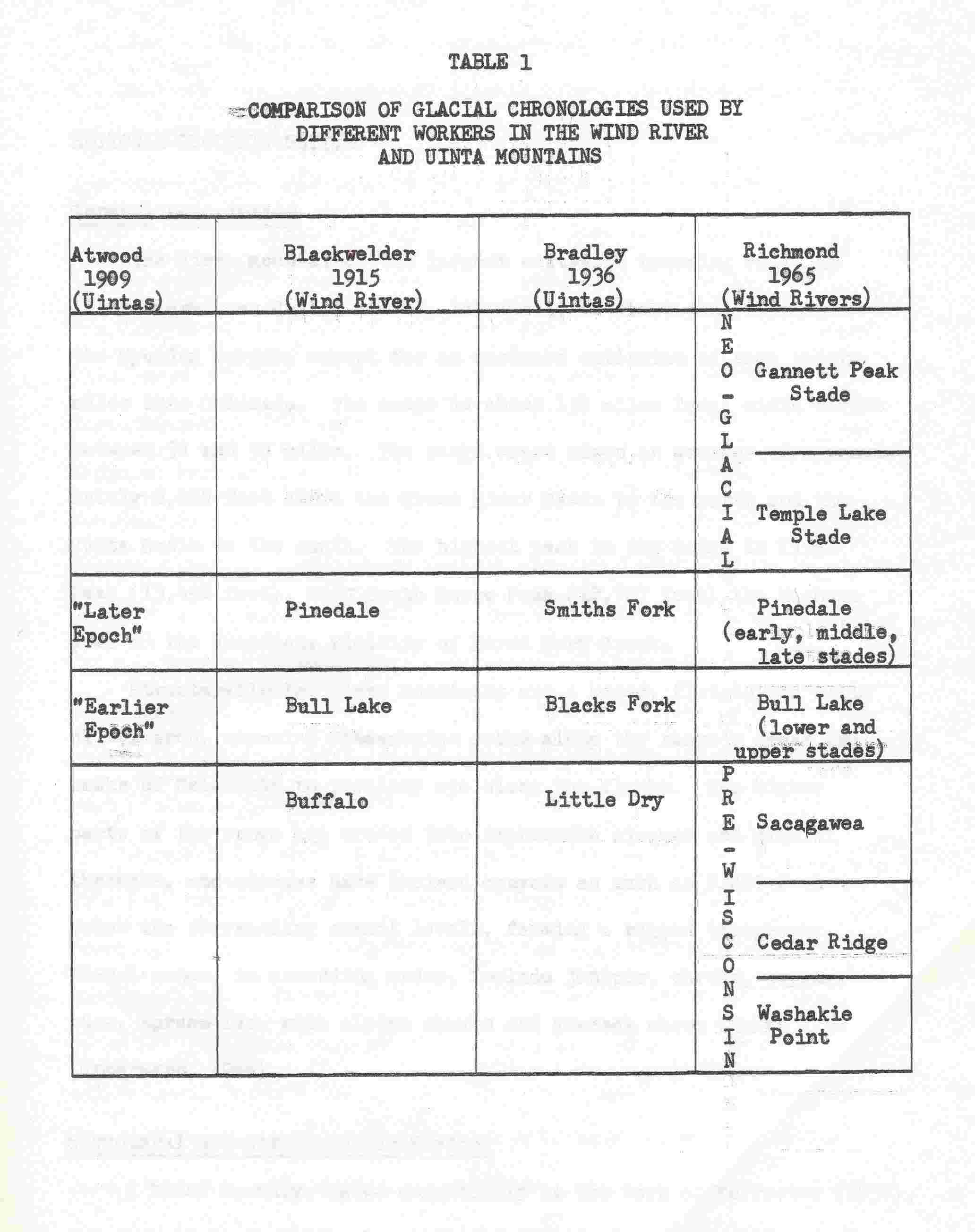
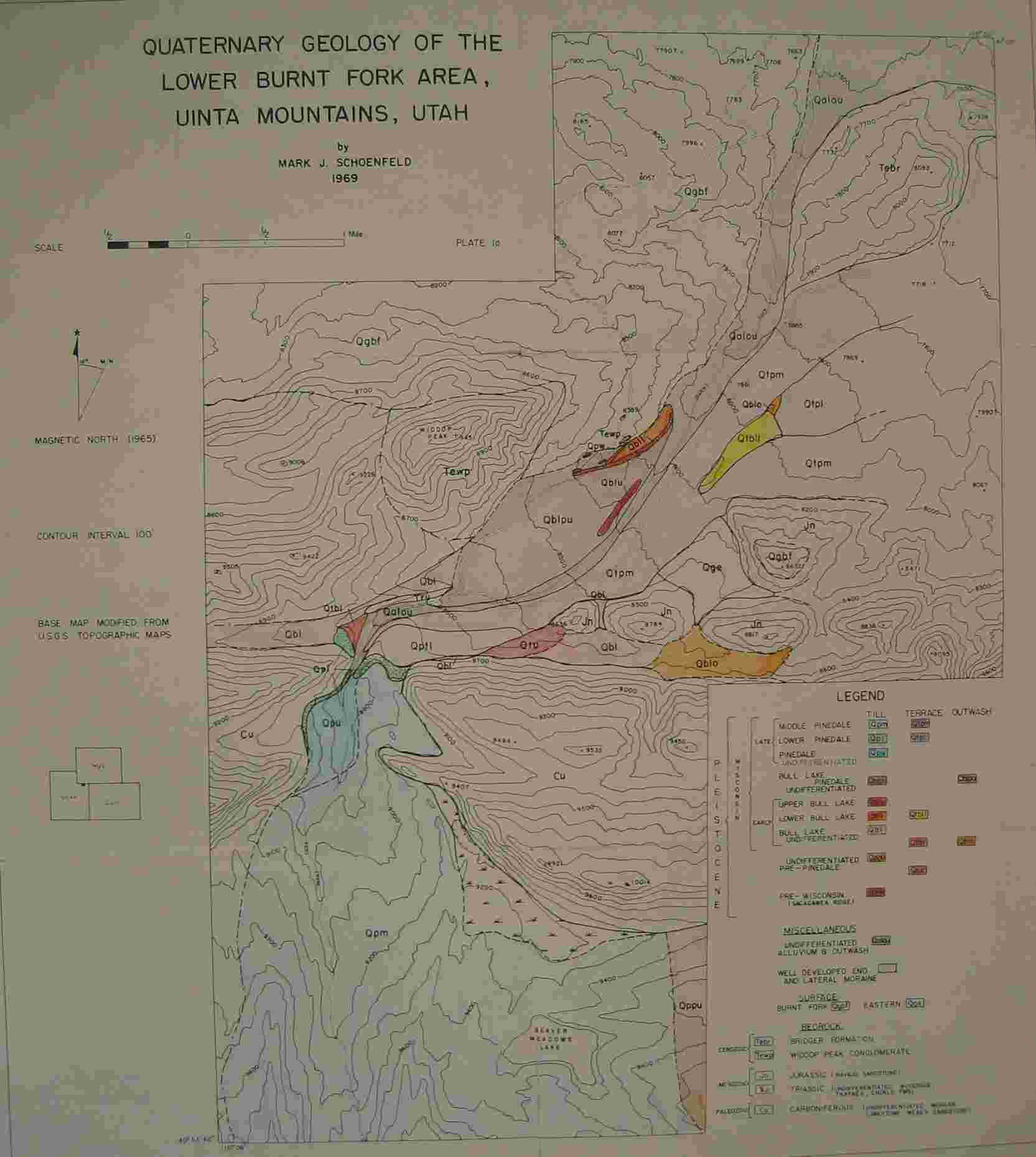
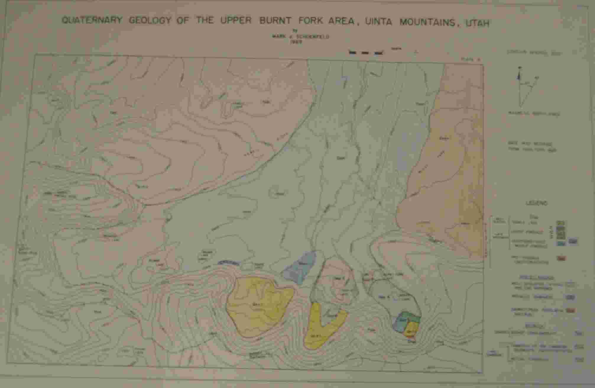
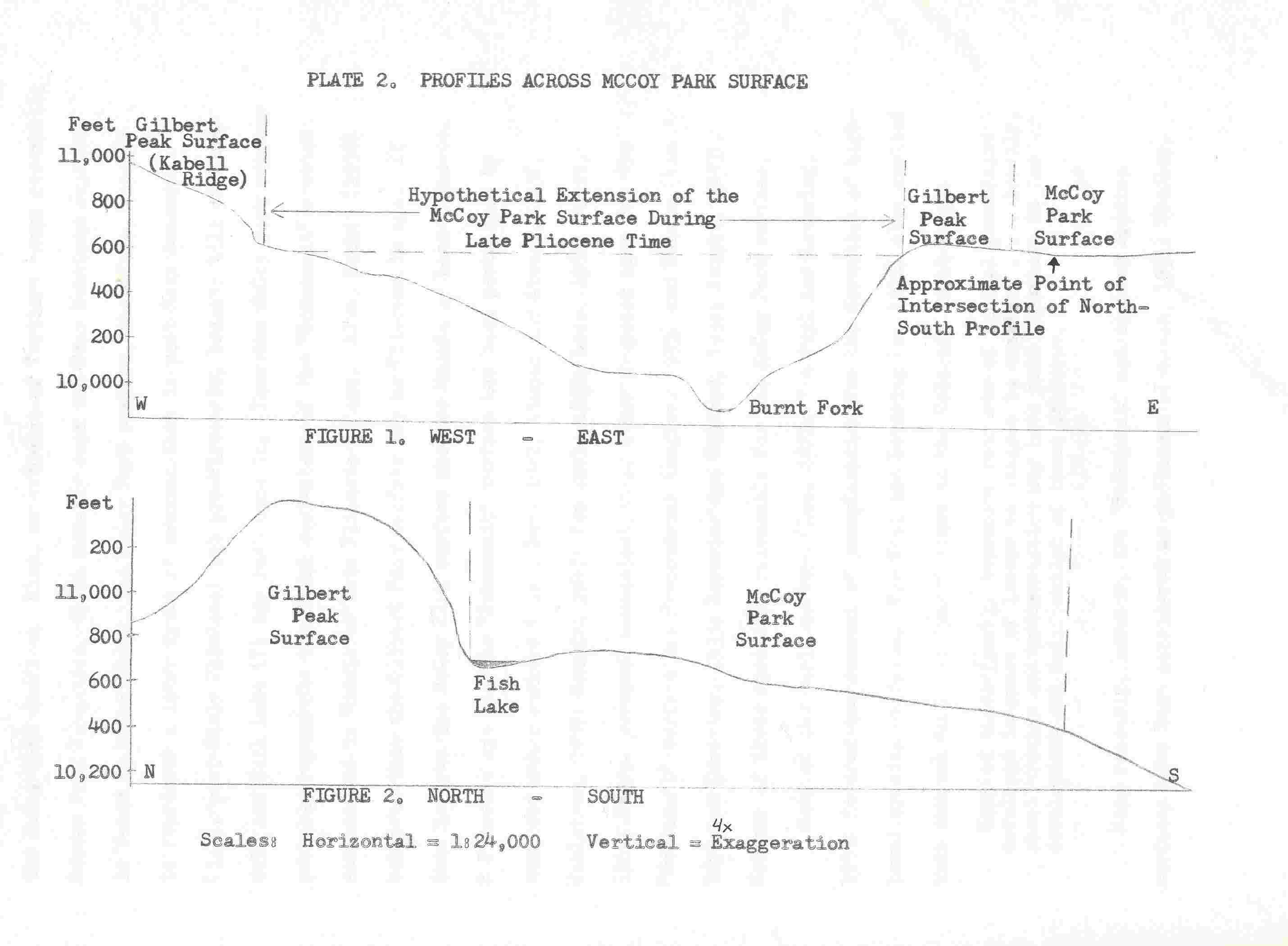
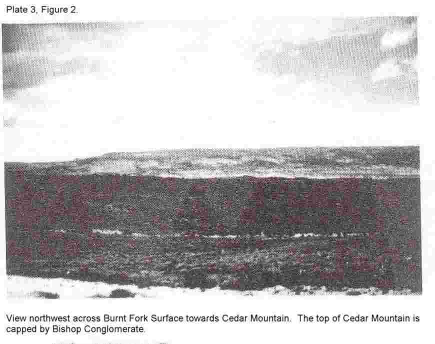
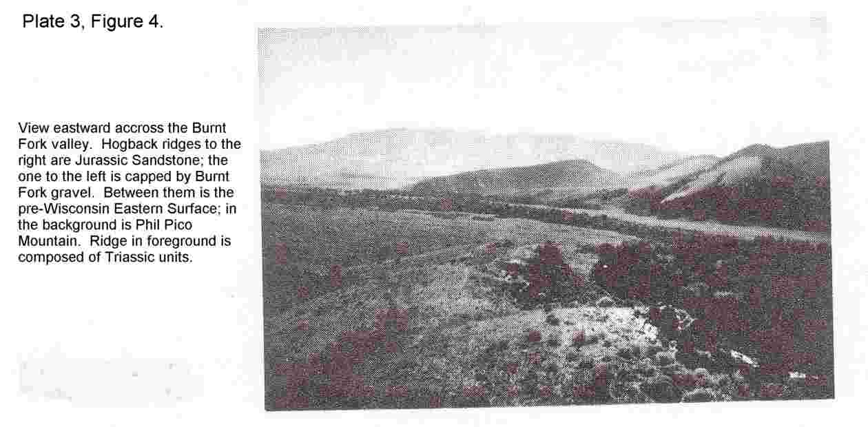
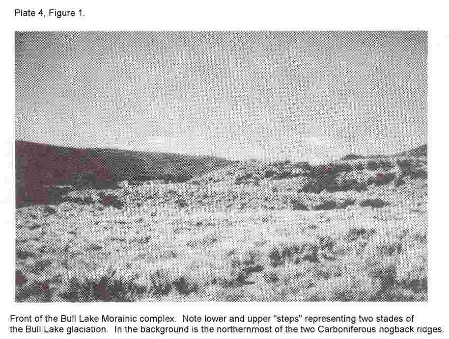
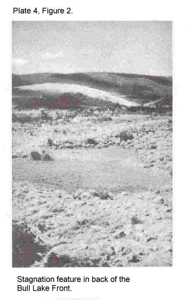
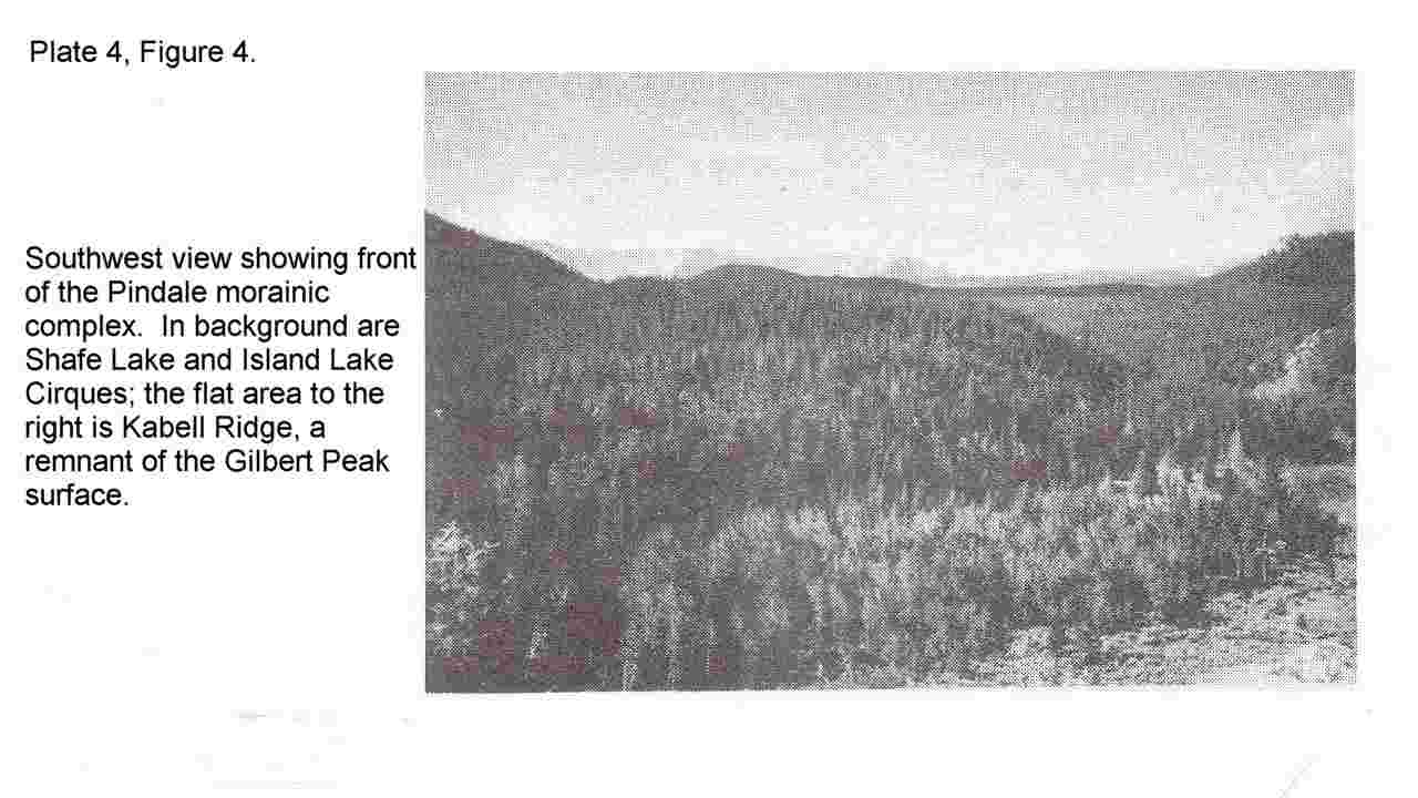
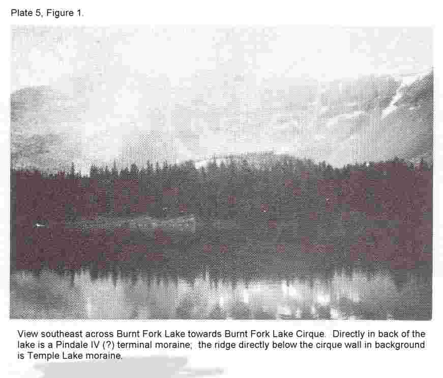
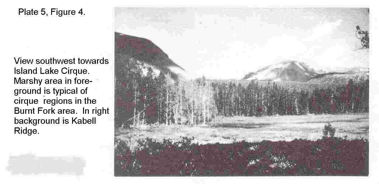
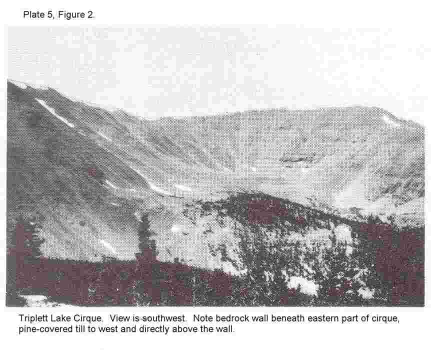
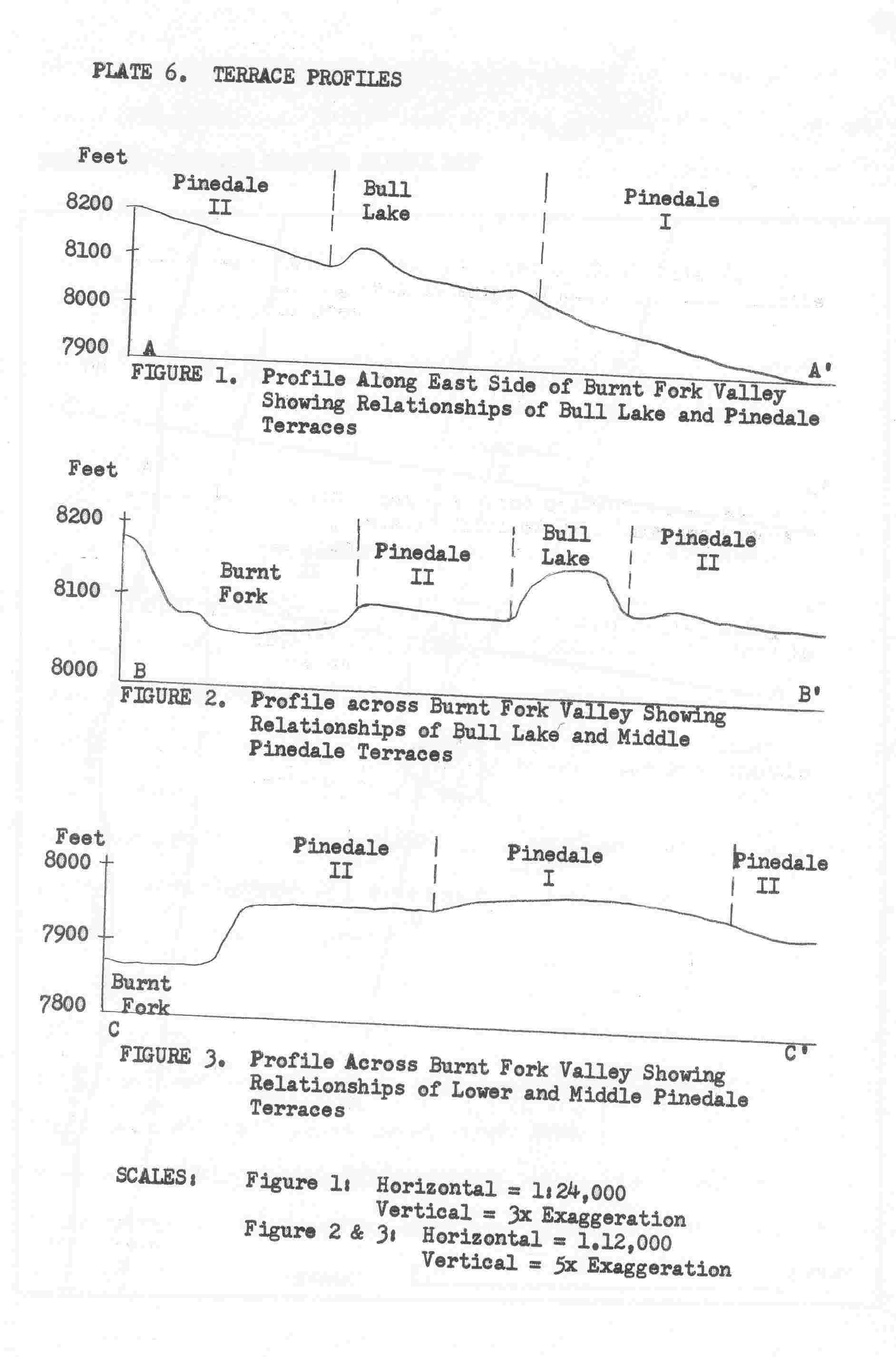
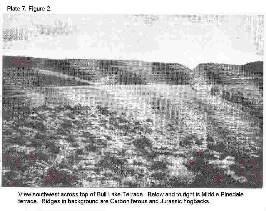
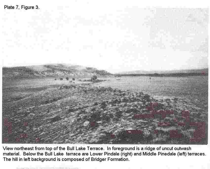
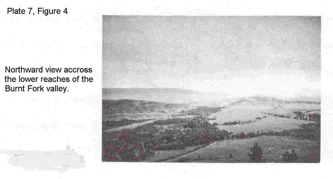